
Website www.ugoccc.us Founded 1854 Unemployment rate 8.6% (Apr 2015) | Area 650.1 km² Population 12,842 (2013) | |
 | ||
Rivers Chattahoochee River, Upatoi Creek, Slaughter Creek | ||
Chattahoochee County, also known as Cusseta-Chattahoochee County, is a county located in the west central portion of the U.S. state of Georgia. As of the 2010 census, the population was 11,267. The county seat is Cusseta, with which the county shares a consolidated city-county government. Despite the city-county government Cusseta is not coterminous with the county; it remains a geographically distinct municipality within the county. The county was created on February 13, 1854.
Contents
- Map of Chattahoochee County GA USA
- History
- Geography
- Major highways
- Adjacent counties
- 2000 census
- 2010 census
- Communities
- References
Map of Chattahoochee County, GA, USA
Chattahoochee County is included in the Columbus, GA-AL Metropolitan Statistical Area.
The county is notable for having the most millennials (15-34 years old) of any county within the United States: 59.7%
History
The Georgia General Assembly created Chattahoochee County on February 13, 1854, from portions of Muscogee and Marion counties. It is named for the Chattahoochee River that forms its western boundary. The county seat was named Cusseta to commemorate the Creek Indian town that once existed nearby. In 2004-2005, the US Census Bureau reported a 6.2% population decline, making it top on the national list of counties with shrinking population.
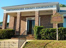
The original courthouse, built in 1854 by slaves, is preserved at the tourist attraction of Westville, near Lumpkin.
Geography
According to the U.S. Census Bureau, the county has a total area of 251 square miles (650 km2), of which 249 square miles (640 km2) is land and 2.4 square miles (6.2 km2) (1.0%) is water.
The vast majority of Chattahoochee County is located in the Middle Chattahoochee River-Walter F. George Lake sub-basin of the ACF River Basin (Apalachicola-Chattahoochee-Flint River Basin). The very small southeastern corner of the county is located in the Kinchafoonee-Muckalee sub-basin of the same larger ACF Basin.
Major highways
Adjacent counties
2000 census
As of the census of 2000, there were 14,882 people, 2,932 households, and 2,624 families residing in the county. The population density was 60 people per square mile (23/km²). There were 3,316 housing units at an average density of 13 per square mile (5/km²). The racial makeup of the county was 58.08% White, 29.92% Black or African American, 0.80% Native American, 1.80% Asian, 0.45% Pacific Islander, 5.18% from other races, and 3.77% from two or more races. 10.42% of the population were Hispanic or Latino of any race.
There were 2,932 households out of which 64.80% had children under the age of 18 living with them, 76.30% were married couples living together, 10.10% had a female householder with no husband present, and 10.50% were non-families. 8.90% of all households were made up of individuals and 2.30% had someone living alone who was 65 years of age or older. The average household size was 3.41 and the average family size was 3.64.
In the county, the population was spread out with 28.40% under the age of 18, 27.90% from 18 to 24, 36.40% from 25 to 44, 5.50% from 45 to 64, and 1.80% who were 65 years of age or older. The median age was 23 years. For every 100 females there were 171.70 males. For every 100 females age 18 and over, there were 217.60 males.
The median income for a household in the county was $37,106, and the median income for a family was $38,313. Males had a median income of $21,975 versus $20,648 for females. The per capita income for the county was $14,049. About 8.90% of families and 10.60% of the population were below the poverty line, including 11.50% of those under age 18 and 18.60% of those age 65 or over.
2010 census
As of the 2010 United States Census, there were 11,267 people, 2,686 households, and 2,067 families residing in the county. The population density was 45.3 inhabitants per square mile (17.5/km2). There were 3,376 housing units at an average density of 13.6 per square mile (5.3/km2). The racial makeup of the county was 68.8% white, 18.8% black or African American, 2.2% Asian, 0.7% American Indian, 0.6% Pacific islander, 4.4% from other races, and 4.4% from two or more races. Those of Hispanic or Latino origin made up 12.4% of the population. In terms of ancestry, 17.5% were German, 14.9% were Irish, 10.1% were English, 6.8% were Italian, and 3.1% were American.
Of the 2,686 households, 53.7% had children under the age of 18 living with them, 57.0% were married couples living together, 16.2% had a female householder with no husband present, 23.0% were non-families, and 19.1% of all households were made up of individuals. The average household size was 2.98 and the average family size was 3.45. The median age was 24.0 years. The county is notable for having the most millennials (15-34 years old) of any county within the United States: 59.7%
The median income for a household in the county was $51,089 and the median income for a family was $55,745. Males had a median income of $41,117 versus $31,422 for females. The per capita income for the county was $22,202. About 14.7% of families and 15.9% of the population were below the poverty line, including 18.4% of those under age 18 and 30.7% of those age 65 or over.