
Length 386.2 km | ||
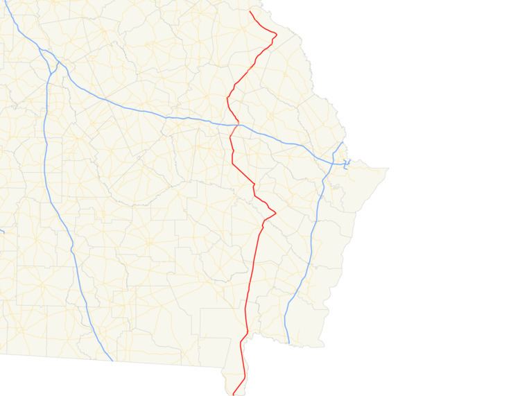 | ||
State Route 23 (SR 23) is a 240.0-mile-long (386.2 km) state highway that travels south-to-north through portions of Charlton, Brantley, Wayne, Long, Tattnall, Candler, Emanuel, Jenkins, and Burke counties in the southeastern and east-central parts of the U.S. state of Georgia. The highway connects the Florida state line, south-southwest of Saint George with the southern part of the Augusta metropolitan area, via Folkston, Nahunta, Jesup, Ludowici, Glennville, Reidsville, Metter, Twin City, and Millen.
Contents
- Map of GA 23 Georgia USA
- Florida to Reidsville
- Reidsville to northern terminus
- National Highway System
- Twin City spur route
- References
Map of GA-23, Georgia, USA
Florida to Reidsville
SR 23 begins at the Florida state line west-northwest of the southernmost point in the state, in Charlton County. South-southeast of here, the roadway continues as State Road 121, which travels to Macclenny, Florida. North-northwest of here, SR 23 travels concurrent with SR 121 on Okefenokee Parkway. Almost immediately, they meet the southern terminus of SR 185. A short distance later, the two highways curve to the northeast. Then, they curve to the north-northwest and enter Saint George. In town, they have an intersection with SR 94 (Moniac Road). The concurrent highways continue to the north-northwest, through rural areas of the county and then curve to the northeast. After that, they enter Folkston, to an intersection with US 1/US 23/US 301/SR 4/SR 15 (2nd Street North). The six highways travel to the north-northwest concurrently. Along the Folkston–Homeland city line, which travels through the large intersection, US 301/SR 23 continue straight ahead, while US 1/US 23/SR 4/SR 15 travel to the northwest. Then, US 301/SR 23 gradually curve to the north-northeast and enter Brantley County. The concurrency enters Nahunta, where it intersects US 82/SR 520 (Cleveland Street). Then, they intersect SR 32 in Hortense, just before entering Wayne County. Just before entering Jesup, they pass by Jesup–Wayne County Airport and Pine Forest Country Club. In town, they intersect US 25/US 341/SR 27 (East Cherry Street). At this intersection, US 25 joins the concurrency. The three highways curve to the north-northwest and intersect US 84/SR 38 (North 1st Street), which join the concurrency. Immediately, the five highways travel north-northeast and then leave town. Just under 3 miles (4.8 km) later, they curve to the northeast. Then, they pass by an industrial waste pond of Rayonier just before crossing over the Altamaha River into Long County. In Ludowici, they intersect SR 57 (Mc Donald Street). At this intersection, US 84/SR 38 split off to the northeast on Cypress Street, while US 25/US 301/SR 23/SR 57 travel to the northwest. The concurrent highways begin a curve to the north-northwest and cross over Beards Creek into Tattnall County. After they meet the western terminus of SR 196, they curve to the north-northeast and enter Glennville. At Barnard Street, they intersect SR 144, and SR 23/SR 57 split off to the northwest. A little over 2,000 feet (610 m) later, SR 144 splits off to the west-southwest on Hencart Road, while SR 23/SR 57 pass by Kicks Playland and leave town. To the northwest, they intersect SR 169. A little farther along, SR 121 rejoins the concurrency. The three highways enter Reidsville.
Reidsville to northern terminus
In Reidsville, SR 23/SR 57/SR 121 intersect US 280/SR 30 (Brazell Street). Before leaving town, they curve to a nearly due-north routing. After that, they curve to the north-northeast and enter Collins, where they intersect SR 292 (Manassas Street). SR 23/SR 57/SR 121 curve to the north-northwest and enter Cobbtown. In town, they meet the eastern terminus of SR 152 (New Cobbtown Road). Approximately 400 feet (120 m) later, SR 57 continues straight ahead, while SR 23/SR 121 curve to the northeast and leave town just before entering Candler County. In Metter, they have an interchange with Interstate 16 (I-16; Jim Gillis Historic Savannah Parkway). In the main part of town, they intersect SR 46 (Broad Street). At this intersection, SR 23 splits off to the west, concurrent with SR 46 for a few blocks, while SR 121 continues straight ahead. At College Street, SR 23 splits off to the north-northeast and gradually curves to the northwest. It passes Candler County Hospital. Just after leaving town, it passes Willow Lake Golf Club and Byrd Cemetery. Farther to the northwest, the highway enters Emanuel County and crosses into the city limits of Twin City. In town, is an intersection with SR 192. At this intersection, SR 23 turns to the right and travels to the northeast. Then, it intersects US 80/SR 26. Just before leaving town, the route passes by Twin City Cemetery. After traveling through Garfield, it enters Jenkins County. The highway passes through rural areas of the county, curves to the east-southeast, and intersects US 25/SR 67/SR 121. The four highways head concurrently to the north-northeast. Then, they curve to the northeast and cross over the Ogeechee River just before entering Millen. In town, they intersect SR 17 Byp. (South Gray Street), which joins the concurrency. The five highways curve to a nearly due-north routing and intersect SR 17 (West Winthrope Avenue). At this intersection, SR 17 Byp. meets its northern terminus and US 25/SR 121 continue straight ahead, while SR 23/SR 67 turn right and follow SR 17 south. At Masonic Street, SR 17 and SR 23 split off to different directions, while SR 67 continues to the east. At Jordan Avenue, SR 23 curves to the northeast. Just after leaving town, it intersects SR 21 (Millen Bypass). Farther to the northeast, it crosses over Beaverdam Creek into Burke County. In Sardis, it intersects SR 24 (Charles Perry Avenue). In Girard, the highway begins a northwesterly routing. The highway enters Shell Bluff, where it intersects SR 80. Then, it passes Hagler Lake before meeting its northern terminus, an intersection with SR 56, just south of Augusta.
National Highway System
There are three segments of SR 23 that are included as part of the National Highway System, a system of roadways important to the nation's economy, defense, and mobility:
Twin City spur route
State Route 23 Spur (SR 23 Spur) is a 472-foot-long (144 m) spur route that exists entirely within the southeastern part of Emanuel County and travels completely within the city limits of Twin City. The highway is known as 5th Avenue for its entire length.
It begins at an intersection with the SR 23 mainline in the southwestern part of town. It travels one block to meet its northern terminus, an intersection with SR 192.
SR 23 Spur is not part of the National Highway System, a system of roadways important to the nation's economy, defense, and mobility.
The entire route is in Twin City, Emanuel County.