
Existed: 1944 – present Length 33.6 km | Constructed 1944 | |
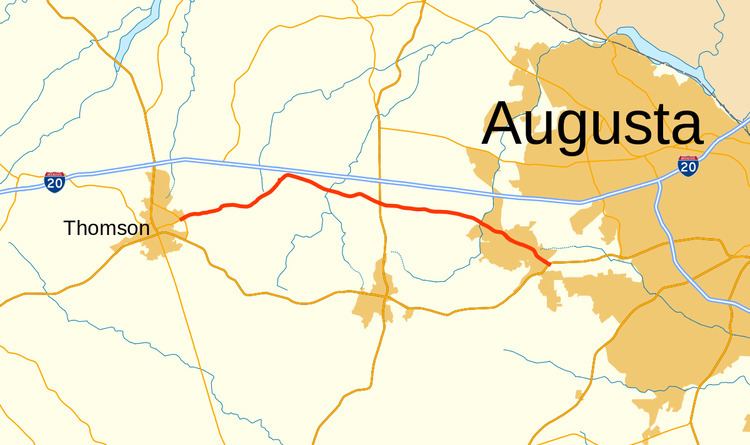 | ||
State Route 223 (SR 223) is a 20.9-mile-long (33.6 km) east–west state highway in the east-central part of the U.S. state of Georgia. Its routing travels through portions of McDuffie, Columbia, and Richmond counties. The highway connects Thomson with Grovetown, Augusta, and Fort Gordon. Except for the portions in Thomson, Grovetown, and Augusta, the highway is relatively rural.
Contents
- Map of GA 223 Georgia USA
- Route description
- 1940s to 1980s
- Former Cedar RockThomson segments routing
- References
Map of GA-223, Georgia, USA
Route description
SR 223 begins at an intersection with SR 17 (Main Street) in Thomson. SR 223 is known as White Oak Street. At the intersection with Holt Street, it curves to the east-southeast and becomes known as White Oak Road. After that, it curves to the east-northeast. On the east edge of town, the highway travels between Thomson High School and Thomson–McDuffie Middle School. Just after leaving the city limits, it has an intersection with US 78/SR 10/SR 17 Byp. (Thomson Bypass). The highway curves to the northeast and enters Columbia County.
Almost immediately, SR 223 curves back to the east-southeast at a point just southeast of White Oak Campground. At the intersection with Hinton Wilson Road, SR 223 becomes known as Wrightsboro Road. Farther to the east, Wrightsboro Road is an important urban corridor in the Augusta metropolitan area. The highway crosses over Kiokee Creek and has a slight northward jog before continuing to the southeast. Approximately 0.5 miles (0.80 km) later, it intersects US 221/SR 47 (Jake Pollard Highway) at a roundabout. The road then curves to a more east-southeasterly routing and crosses over Little Kiokee Creek. Then, it travels just south of Euchee Creek Elementary School and Euchee Creek Library. A short distance later, the roadway crosses over the northern terminus of the Grovetown Trails at Euchee Creek, briefly skirting along the northwestern city limits of Grovetown in the process. A few hundred feet later, the highway enters Grovetown proper and has an intersection with the eastern terminus of Harlem–Grovetown Road. This intersection also marks the southern terminus of SR 388, which takes on the "Wrightsboro Road" name, while SR 223 continues known as Robinson Avenue. The highway travels through town and enters Richmond County and the city limits of Augusta. It immediately meets its eastern terminus, an intersection with US 78/US 278/SR 10 (Gordon Highway). The roadway continues to Fort Gordon's Gate 2. Just like nearby SR 383, this highway serves as an important access route from the Army base to the local area. The only segment of SR 223 that is included as part of the National Highway System, a system of routes determined to be the most important for the nation's economy, mobility and defense, is from just west of the SR 388 intersection in Grovetown to its eastern terminus in Augusta.
1940s to 1980s
SR 223 was established in 1943 along an alignment from an intersection with SR 12 (which currently also carries US 278) in Norwood northeast to an intersection with SR 80 in Cadley. By 1948, the Cedar Rock–Thomson segment was opened. It is unknown whether it was concurrent with SR 80 in-between the two segments. Both of the segments had a "sand clay, top soil, or stabilized earth" surface. A small piece of SR 80 just northwest of Cedar Rock also had a sand clay, top soil, or stabilized earth surface. By 1952, the two separate segments of SR 223 were hard surfaced. In 1955, the road that would eventually become the Thomson–Augusta segment was built and hard surfaced. By 1963, the Thomson–Augusta segment was designated as SR 223, and the entire length of the highway, from Norwood to Augusta, was paved. By 1982, the original Norwood–Cedar Rock segment was decommissioned.
Former Cedar Rock–Thomson segment's routing
Between 1982 and 2013, SR 223 used to travel between Cedar Rock and Thomson. It began at an intersection with SR 80, in the unincorporated community of Cedar Rock. This is just west of the Warren–McDuffie county line. SR 223 was known as Norwood Road at its former western terminus. It traveled to the north-northeast and very quickly changed to Cedar Rock Road. The highway curved to the east-southeast and crossed over Childers Creek. At its intersection with Sallywhite Road, it began to curve to the east-northeast. The highway passed Ivey Cemetery just before it curved to the southeast. It crossed over, but did not have an interchange with, Interstate 20 (I-20; Carl Sanders Highway). Approximately 2,500 feet (760 m) later, SR 223 curved back to the east-northeast, but quickly curved to the east-southeast. Just after crossing over Mattox Creek, it curved to the south-southeast, and entered Thomson. At the city limits, the highway was known as Hickory Hill Drive and passed by Hickory Hill, a historic house museum, which is a National Historic Landmark, it was a home of Georgia Populist Party co-founder Thomas E. Watson. At the intersection with Lee and Lumpkin Streets, SR 223 was known as Tom Watson Way (named for Thomas E. Watson. Just after passing the Thomson City Cemetery, it intersected SR 17 (Main Street) and the western terminus of SR 150 (Gordon Street). SR 17/SR 223 traveled concurrently to the south-southeast for about four blocks, where SR 223 split off to the northeast on White Oak Street, as it currently travels. Between 2011 and 2013, this segment of the highway was decommissioned.