
Length 244.6 km | ||
 | ||
Counties | ||
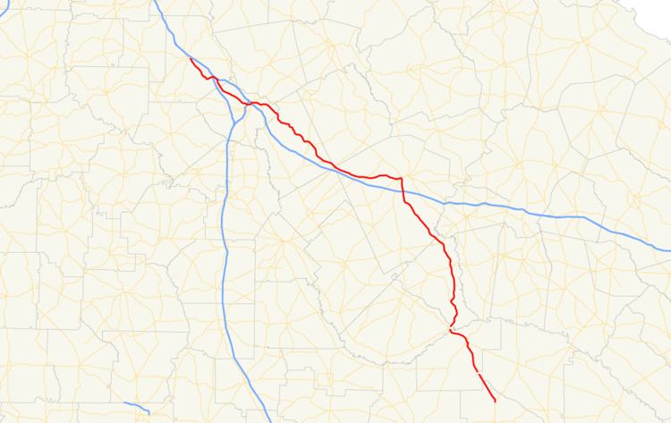
State Route 19 (SR 19) is a 152-mile-long (245 km) state highway that travels southeast-to-northwest through portions of Bacon, Jeff Davis, Appling, Telfair, Wheeler, Laurens, Twiggs, Bibb, and Monroe counties in the central part of the U.S. state of Georgia. The highway travels from its southern terminus at US 1/US 23/SR 4 north of Alma to its northern terminus at US 41/SR 18 in Forsyth.
Contents
Map of GA-19, Georgia, USA
Route description
SR 19 begins at an intersection with US 1/SR 4 north of Alma. The route travels north, concurrent with US 23, which is also concurrent with US 1/SR 4 south of here. In Hazlehurst, US 341/SR 27 join the concurrency. In Lumber City, SR 19 departs to the north, crossing the Little Ocmulgee River, and begins to parallel the Oconee River north to Dublin. In Dublin, SR 19 travels concurrent with US 80. The two highways travel west to Macon. In Macon, SR 19 leaves US 80 and travels concurrent with US 23 again, and later, US 41. The highways travel north to Forsyth, where SR 18 travels concurrent with US 41, and SR 19 meets its northern terminus.
In 1998, the Georgia state legislature passed a resolution designating a portion of SR 19 in Macon as "Duane Allman Boulevard" and a bridge thereon as "Raymond Berry Oakley III Bridge" in honor and remembrance of late founding members of The Allman Brothers Band.
The following segments of SR 19, that are concurrent with U.S. Highways, are the only segments that are included as part of the National Highway System, a system of roadways important to the nation's economy, defense, and mobility
Hazlehurst connector route
State Route 19 Connector (SR 19 Conn.) is a 0.2-mile-long (0.32 km) connector route that exists entirely within the city limits of Hazlehust in the north central part of Jeff Davis County, and is known as East Coffee Street for its entire length.
It begins at an intersection with US 221/SR 135 (South Tallahassee Street) in the central part of Hazlehurst. It heads northeast for two blocks and has a slight curve to the east. At that point, it meets its northern terminus, an intersection with US 23/US 341/SR 19/SR 27.
SR 19 Conn. is not part of the National Highway System, a system of roadways important to the nation's economy, defense, and mobility.
The entire route is in Hazlehurst, Jeff Davis County.