
Length 26.9 km | ||
 | ||
Counties | ||
State Route 190 (SR 190) is a 16.7-mile-long (26.9 km) state highway that runs west-east mostly through F. D. Roosevelt State Park and Roosevelt's Little White House Historic Site. It is known as Scenic Heights Road and Pine Mountain Highway. It connects the Pine Mountain area and Manchester.
Contents
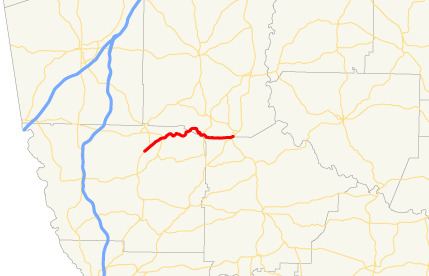
Map of GA-190, Georgia, USA
Route description
SR 190 begins at an intersection with US 27/SR 1, south of Pine Mountain, in Harris County. It heads northeast and meets SR 354 in the park. After leaving the park it enters Roosevelt's Little White House Historic Site. In the historic site, just north of Dowdell's Knob, it crosses into Meriwether County. On the southeast edge of the site, it intersects US 27 Alternate/SR 85 Alternate (Whitehouse Highway). It enters Talbot County and parallels the northwestern border of the county. Finally, it crosses back into Meriwether County and enters Manchester. It heads northeast until it meets its eastern terminus, an intersection with SR 41/SR 85 (Broad Street).
SR 190 is not part of the National Highway System, a system of roadways important to the nation's economy, defense, and mobility.
At the intersection of the eastern terminus lies Georgia State Patrol's Post 34, also known as the Manchester Post. State Route 190 is used to access several broadcast towers including WFDR-FM, WFDR (AM), and WVFJ-FM. On top of the mountain, S.R. 190 passes over State Route 354 on a historic bridge built by the Civilian Conservation Corps. This route also contains many lookout points for photography.