
 | ||
The regional geology of Serbia describes the geologic structure and history inside the borders of Serbia.
Contents
- Sava Zone
- Jadar Kopaonik thrust sheet
- Supragetic
- Drina Ivanjica thrust sheet
- Seismic activity
- History of geologic investigation
- References
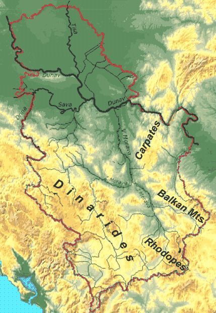
Serbia is in recent geologic time a part of the Eurasian Plate, but the bedrock lithologies are witness to a diverse geologic history. In a tectonic sense, Serbia is part of an orogenic system that is composed of the Alpine, Carpathian, and Dinaride orogenic belts. Its territory can be divided into five geotectonic units of differing genesis:
Sava Zone
The Sava Zone (named after the river Sava) is an oceanic suture that strikes roughly NNW to SSE through Serbia and is mostly covered in the north by the sediments of the Pannonian Basin. Outcrops can be found in the Fruška Gora (Fruška mountains). Here the unit is composed of blueschists and ophiolites. In the south outcrops of the Sava Zone occur in the Balkan and Rhodope Mountains. This includes the Senonian Flysch and the rocks cropping out in the Jastrebac Window.
Jadar-Kopaonik thrust sheet
The Jadar-Kopaonik Thrust Sheet is a NW-SE striking unit in the southern footwall of the Sava Zone and the northern hangingwall of the Drina-Ivanjica Thrust Sheet. Most of the outcrops are ophiolites from the Western Vardar ocean, but there are some windows into the underlying basement. The Jadar unit in western Serbia (Jadar Region) is the largest window into the underlying Adriatic units of the Jadar-Kopaonik Thrust Sheet. Two smaller windows crop out farther to the south. The Studenica unit lies in the west and the Kopaonik unit in the east of the thrust sheet.
Supragetic
The Supragetic nappes form a N-S striking belt in eastern Serbia, where they crop out in the Balkan Mountains (Stàra planinà). They are part of the paleogeographic realm of Dacia. The Supragetic is subdivided into the Ranovac and Vlasina unit.
Drina-Ivanjica thrust sheet
The Drina-Ivanjica thrust sheet forms a NNW to SSE striking thrust sheet through southwestern Serbia. It is composed of a Paleozoic basement and Mesozoic cover. On top of this lies the obducted Zlatibor ophiolite (Zlatibor mountains), a remnant of the Western Vardar ocean.
Seismic activity
Serbia is prone to moderate to strong seismic activity, especially in the central belts of Vardar Zone and Serbian Massif. Major earthquakes in the 20th century ranged between 5.0 from 6.0 (Lazarevac 1922) Richter scale. The last major earthquake at 5.4 occurred near Kraljevo on 3 November 2010.
List of major earthquakes in the 20th and 21st centuries:
History of geologic investigation
The Serbian Geologic Society was established by a group of professors and students in Belgrade on 10 February 1891 under the leadership of Jovan Žujović. The geologic survey was founded 29 December 1930.