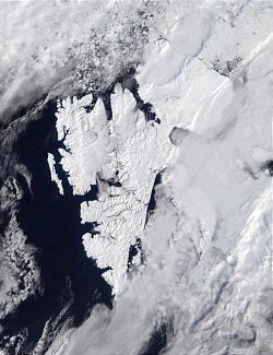
Svalbard is an archipelago in the Arctic Ocean roughly centered on 78° north latitude and 20° east longitude. The archipelago is the northernmost part of the Kingdom of Norway. The three main islands in the group consist of Spitsbergen (the largest island), Nordaustlandet and Edgeøya. There are also a number of smaller islands, such as Barents Island (Barentsøya) (1,288 km2 (497 sq mi)), Kvitøya (682 km2 (263 sq mi)), Prins Karls Forland (English: Prince Charles Foreland) (615 km2 (237 sq mi)), Kongsøya (191 km2 (74 sq mi)), Bear Island (178 km2 (69 sq mi)), Svenskøya (137 km2 (53 sq mi)), Wilhelm Island (120 km2 (46 sq mi)) and other smaller islands or skerries (621 km2 (240 sq mi)).
There is no arable land in the island group due to heavy glaciation and the northern latitude. There are no trees native to the archipeligo, but there are shrubs such as crowberry and cloudberry. The west coast of Spitsbergen remains navigable most of the year, due to favorable winds which keep the area ice-free. Norway claims a 200 nmi (370.4 km; 230.2 mi) fishery protection zone, but this is not recognized by neighboring Russia.
The climate of the Svalbard archipeligo is arctic, tempered by warm North Atlantic Current along the west and northern coasts. This means cool summers and cold winters along the wild, rugged mountainous islands. The high land of the island interiors is generally ice covered year round, with the west coast clear of ice about one half of the year. There are many fjords along west and north coasts
Lands
The main islands of Svalbard is parted into several lands:
Spitsbergen:Albert I LandHaakon VII LandAndrée LandPrins Karls ForlandOscar II LandJames I LandDickson LandNy-FrieslandOlav V LandBünsow LandSabine LandNordenskiöld LandHeer LandNathorst LandWedel Jarlsberg LandTorell LandSørkapp LandNordaustlandetGustav V LandPrins Oscars LandOrvin LandGustav Adolf LandThere are numerous fjords among the Svalbard islands; the five longest of which (measured from the head to open sea) are listed here:
Wijdefjorden, 108 km (67 mi)Isfjorden, 107 km (66 mi)Van Mijenfjorden, 83 km (52 mi)Woodfjorden, 64 km (40 mi)Wahlenbergfjord, 46 km (29 mi)Coastlines of the Svalbard islands (listed from largest island to smallest) show the extensive variability characteristic of glacial formation:
Spitsbergen, 3,919 km (2,435 mi)Nordaustlandet, 1,688 km (1,049 mi)Edgeøya, 502 km (312 mi)Barentsøya, 205 km (127 mi)Kvitøya, 119 km (74 mi)Prins Karls Forland, 320 km (200 mi)Kongsøya, 132 km (82 mi)Bear Island (Bjørnøya), 88 km (55 mi)Hopen, >66 km (41 mi)Svenskøya, 62 km (39 mi)Wilhelm Island, 58 km (36 mi)Other smaller islands and skerries, 1,736 km (1,079 mi)Although they are small when compared with the mountains of Norway, the elevation of the Svalbard island mountains accounts for much of the glacial erosion:
Newtontoppen, 1,713 m (5,620 ft)Perriertoppen, 1,712 m (5,617 ft)Ceresfjellet, 1,675 m (5,495 ft)Chadwickryggen, 1,640 m (5,380 ft)Galileotoppen, 1,637 m (5,371 ft)Austfonna (with Sørfonna and Vegafonna), 8,492 km2 (3,279 sq mi)Olav V Land, 4,150 km2 (1,600 sq mi)Vestfonna, 2,505 km2 (967 sq mi)Åsgårdfonna, 1,645 km2 (635 sq mi)Edgeøyjøkulen, 1,300 km2 (500 sq mi)Hinlopenbreen, 1,248 km2 (482 sq mi)Negribreen, 1,182 km2 (456 sq mi)Bråsvellbreen, 1,160 km2 (450 sq mi)Etonbreen, 1,070 km2 (410 sq mi)Leighbreen, 925 km2 (357 sq mi)Holtedahlfonna (with Isachsenfonna), 900 km2 (350 sq mi)Kvitøyjøkulen (Kvitøya (island)), 705 km2 (272 sq mi)Stonebreen, 700 km2 (270 sq mi)Kronebreen, 700 km2 (270 sq mi)Hochstetterbreen, 581 km2 (224 sq mi)Barentsjøkulen, 571 km2 (220 sq mi)Balderfonna, 543 km2 (210 sq mi)Nathorstbreen, 489 km2 (189 sq mi)Monacobreen, 408 km2 (158 sq mi)AgardhelvaBungeelvaGrøndalselvaLidelvaLongyear RiverReindalselvaSassenelvaSemmeldalselvaSlaklielvaVindaBarentsburg (Баренцбург) (Russian settlement — population of 400)Bear Island (Norwegian weather station, population of 9)Hopen (Norwegian weather station, population of 4)Hornsund (Polish research station, population of 8)Longyearbyen (population of ≈2,000)Ny-Ålesund (population of 40)Sveagruva (population of 310, none living permanently)No roads link the settlements on the island; transportation includes boat, airplane, helicopter, and snowmobile. The gateway to Svalbard is Svalbard Airport, Longyearbyen.
Harlingen kokerij (Dutch settlement established in 1636 in Houcker Bay, abandoned sometime after 1662)Kobbefjorden (also Robbe Bay or Copenhagen Bay) (Danish settlement established in 1631, abandoned in 1658)Engelskbukta (English settlement established around 1615, occupied until mid-century)Gravneset (English settlement established in the early 17th century, abandoned between 1624 and 1632, after which time it was appropriated by the Dutch)Grumant (Grumantbyen) (Грумант) (Russian settlement, abandoned in 1961, revival of mining operations announced in 2003)Gåshamna (Two English settlements, established sometime around 1618 and occupied until at least 1655)Lægerneset (Dutch settlement appropriated by the English in 1615, occupied by the latter until the 1650s)Port Louis (French settlement established in 1633, abandoned in 1637)Pyramiden (Пирамида) (Russian settlement, abandoned in 1998)Smeerenburg (Danish-Dutch settlement established in 1619 on the southeastern promontory of Amsterdam Island, abandoned around 1660)Ytre Norskøya (Dutch settlement possibly rivaling Smeerenburg in size; probably established by members of the Zeeland chamber in the 1620s or later, and abandoned in 1670)