
 | ||
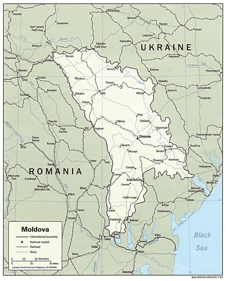
Located in southeastern Europe, Moldova is bordered on the west and southwest by Romania and on the north, south, and east by Ukraine. Most of its territory lies between the area's two main rivers, the Dniester and the Prut. The Dniester forms a small part of Moldova's border with Ukraine in the northeast and southeast, but it mainly flows through the eastern part of the country, separating Bessarabia and Transnistria. The Prut River forms Moldova's entire western boundary with Romania. The Danube touches the Moldovan border at its southernmost tip, and forms the border for 200 m (656 ft).
Contents
- Extreme points
- Climate
- Topography
- Natural habitat
- Historical references
- Current issues
- International environmental agreements
- References
Phytogeographically, Moldova is shared between the Central European and Eastern European provinces of the Circumboreal Region within the Boreal Kingdom. According to the WWF, the territory of Moldova can be subdivided into three ecoregions: the Central European mixed forests, the East European forest steppe (the most territory of the country), and Pontic steppe (in the south and southeast).
Extreme points
Climate
Moldova's proximity to the Black Sea gives it a mild and sunny climate.
Moldova's climate is moderately continental: the summers are warm and long, with temperatures averaging about 20 °C (68 °F), and the winters are relatively mild and dry, with January temperatures averaging −4 °C (25 °F). Annual rainfall, which ranges from around 6 centimeters (2.4 in) in the north to 4 centimeters (1.6 in) in the south, can vary greatly; long dry spells are not unusual. The heaviest rainfall occurs in early summer and again in October; heavy showers and thunderstorms are common. Because of the irregular terrain, heavy summer rains often cause erosion and river silting.
Weather records. The highest temperature ever recorded: +41.5 °C (106.7 °F) on July 21, 2007 (Camenca). The lowest temperature ever recorded: −35.5 °C (−31.9 °F) on January 20, 1963 (Brătuşeni, Edineţ county).
Chişinău's climate. (Central Moldova)
Bălţi's climate. (Northern Moldova)
Tiraspol's climate. (Central Moldova)
Cahul's climate. (Southern Moldova)
Topography
Most of Moldova's territory is a moderate hilly plateau cut deeply by many streams and rivers. Geologically, Moldova lies primarily on deep sedimentary rock that gives way to harder crystalline outcroppings only in the north. Moldova's hills are part of the Moldavian Plateau, which geologically originate from the Carpathian Mountains.
The northern landscape of Moldova is characterized by gently rolling uplands of the Dniester Hills (up to 300 m or 984 ft, in elevation) interlaced with small flat plains in the valleys of the numerous creeks (at 150 m or 492 ft elevation). These hills, which have an average altitude of 240 meters (787 ft) and a maximum altitude of 320 meters (1,050 ft), can be divided into the Northern Moldavian Hills and the Dniester Ridge, and continue further occupying the northern part of the Chernivtsi oblast in Ukraine. The eastern slopes of the Dniester Ridge (average 250 meters or 820 feet, max 347 meters or 1,138 feet), form the high right bank of the Dniester River.
The Moldavian Plain has an average of 200 meters (656 ft) and a maximum altitude of 250 meters (820 ft), and can be divided into the Bălţi Steppe and the Middle Prut Valley. Originally forested, it has been extensively de-forested for agriculture during the 19th and 20th centuries. In contrast to the region to the north and south, which is smore slant, this area is referred to as plain, although it has relief very different from that of a flatland, and vegetation different from that of the steppe.
The hills of central Moldova, the Central Moldavian Plateau, at an average elevation of about 350 to 400 m (1,148 to 1,312 ft), are ridges interlaced by deep, flat valleys, ravines, and landslide-scoured depressions. Steep forest-clad slopes account for much of the terrain, where the most common trees are hornbeam, oak, linden, maple, wild pear, and wild cherry. The term Codri refers more generally to all the forests between the Carpathians and the Dniester river, and even more generally to all forests in the area of the Carpathians, yet since in Moldova most of them were preserved in the central part, Codri sometimes can colloquially refer to the remaining forests in the hills west and north of Chişinău. The Dniester Ridge border Central Moldavian Plateau to the north along the river Răut.
The plateau can be divided into 5 parts: Ciuluc-Soloneţ Hills (Romanian: Dealurile Ciuluc-Soloneţ), alongated in the north along the right side of the Răut river, 1,690 km2 (653 sq mi), Corneşti Hills (Romanian: Dealurile Corneştilor), also known as Cordi Hills (Romanian: Dealurile Codrilor), 4,740 km2 (1,830 sq mi), Lower Dniester Hills (Romanian: Dealurile Nistrului Inferior), alongated to the south of the Botna river, 3,040 km2 (1,174 sq mi), Tigheci Hills (Romanian: Dealurile Tigheciului), alongated in the south along the left side of the Prut river, 3,550 km2 (1,371 sq mi), and between the latter and the Prut river, the Lower Prut Valley (Romanian: Valea Prutului Inferior), 1,810 km2 (699 sq mi).
The country's highest point, Bălăneşti Hill, which reaches 1,407 or 1,410 ft (428.9 or 429.8 m), depending on the source, is situated in the Corneşti Hills, the western part of the Central Moldavian Plateau. Northwest of it are the Ciuluc-Soloneţ Hills (average 250 meters or 820 feet, max 388 meters or 1,273 feet). In the south, the Tigheci Hills (average 200 meters or 656 feet, max 301 meters or 988 feet) are a prolongation, and run to the south parallel to the Lower Prut Valley.
To the south-east, the southern part of the Central Moldavian Plateau, which averages 150–200 meters (492–656 ft), max 250 meters (820 ft), and has numerous ravines and gullies, gradually vanishs into the extensive Bugeac Plain, with most of the Budjak region already in Ukraine.
Transnistria (the left bank of the Dniester) has spurs of the Podolian Plateau (Romanian: Podişul Podoliei, Ukrainian: Volyno-Podil's'ka vysochyna), (average 180 meters or 591 feet, max 275 meters or 902 feet), which are cut into by tributaries of the Dniester River. The southern half of Transnistria, the Lower Dniester Plain, can be regarded as the western end of the Eurasian steppe, and has an average elevation of 100 meters (328 ft), with a maximum of 170 meters (558 ft). The high right bank and low left bank of the Dniester are in sharp contrast here, where visibility is not impeded by forests.
About 75 percent of Moldova is covered by a soil type called black earth or chernozem. In the northern hills, more clay textured soils are found; in the south, red-earth soil is predominant. The soil becomes less fertile toward the south but can still support grape and sunflower production. The hills have woodland soils, while a small portion in southern Moldova is in the steppe zone, although most steppe areas today are cultivated. The lower reaches of the Prut and Dniester rivers and the southern river valleys are saline marshes.
Drainage in Moldova is to the south, toward the Black Sea lowlands, and eventually into the Black Sea, but only eight rivers and creeks extend more than 100 kilometers. Moldova's main river, the Dniester, is navigable throughout almost the entire country, and in warmer winters it does not freeze over. The Prut river is a tributary of the Danube, which it joins at the far southwestern tip of the country. Over 95% of the water circulation in Moldova flows into one of the two rivers - the Prut or Dniester. Of Moldova's well-developed network of about 3,000 creeks and streams, all draining south to the Black Sea, only 246 exceed 6 mi (9.7 km) in length, and only 8 exceed 60 mi (96.6 km).
Underground water, extensively used for the country's water supply, includes about 2,200 natural springs. The terrain favours construction of reservoirs of various size.
Elevation extremes:
lowest point: an unnamed point on the bank of the Dniester River 2 m (6.56 ft)
highest point: Dealul Bălăneşti 430 m (1,411 ft)
Natural habitat
Moldova's natural habitat is characterized by forest steppes, a temperate-climate habitat type composed of grassland interspersed with areas of woodland or forest. A belt of forest steppes cross Eurasia from eastern Europe to Eastern Siberia, forming a transition between temperate broadleaf and mixed forests and temperate grasslands. In the 19th century Moldova witnessed a sharp decrease in the forested areas, sacrificed for agriculture due to rich soil.
Historical references
Current issues
Moldova's communist-era environmental legacy, like that of many other former Soviet republics, is one of environmental degradation. Agricultural practices such as overuse of pesticides and artificial fertilizers were intended to increase agricultural output at all costs, without regard for the consequences. As a result, Moldova's soil and groundwater were contaminated by lingering chemicals, some of which (including DDT) have been banned in the West.
Such practices continue in Moldova to the present day. In the early 1990s, use of pesticides in Moldova averaged approximately twenty times that of other former Soviet republics and Western nations. In addition, poor farming methods, such as destroying forests to plant vineyards, have contributed to the extensive soil erosion to which the country's rugged topography is already prone.
International environmental agreements
party to: Air Pollution, Air Pollution-Persistent Organic Pollutants, Biodiversity, Climate Change, Climate Change-Kyoto Protocol, Desertification, Endangered Species, Hazardous Wastes, Ozone Layer Protection, Ship Pollution, Wetlands
signed, but not ratified: none of the selected agreements