
 | ||
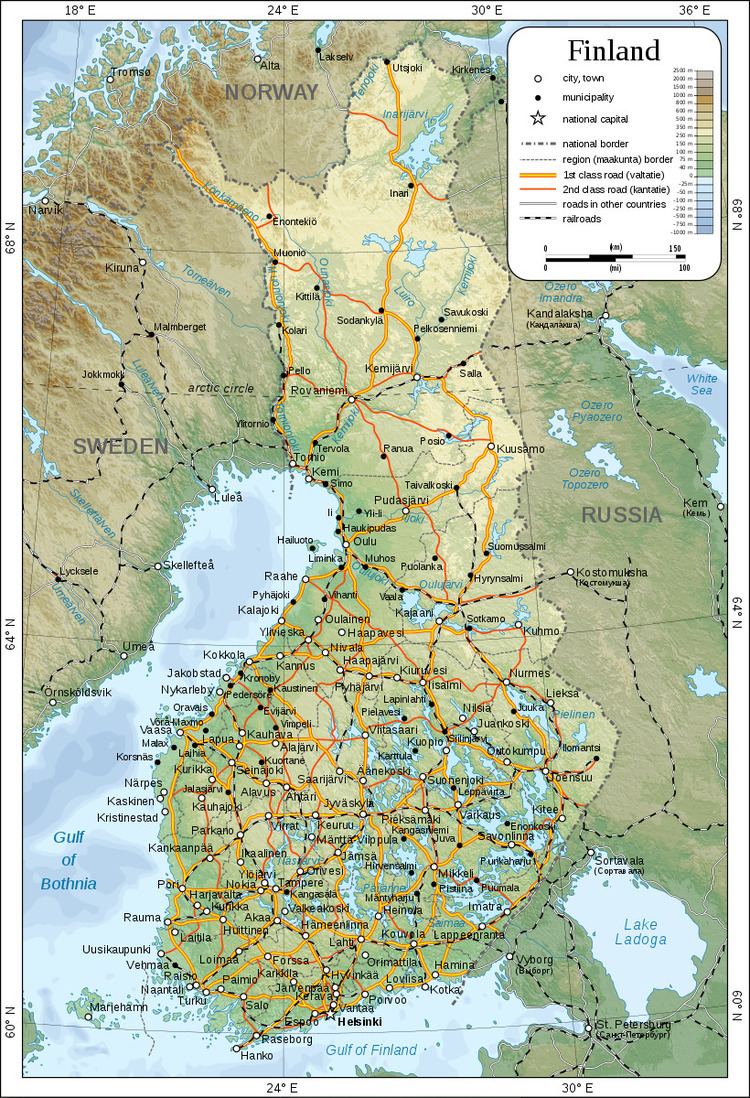
The geography of Finland differs from that of other Nordic countries. Bordering the Baltic Sea, Gulf of Bothnia, and Gulf of Finland, as well as Sweden, Norway, and Russia, Finland is the northernmost country in the European Union. Although other countries have points extending north, virtually all of Finland is north of 60 degrees north latitude.
Contents
Landform regions
Many countries of the world can be divided into distinct geographic regions, in each of which some physical characteristic is dominant, almost to the exclusion of others. In Finland, the same physical characteristics are common to each of the four geographic regions into which the country is divided. Regional differences in Finland lie, therefore, in subtle combinations of physical qualities. In archipelago Finland, rock and water are dominant. Coastal Finland consists of broad clay plains where agriculture plays a leading role. The interior Finnish lake district supports extensive forests. Upland Finland is covered by Arctic scrub. Finland lacks true arctic tundra but has alpine tundra on top of fells.
Archipelago Finland, consisting of thousands of islands and skerries, extends from the southwestern coast out into the Baltic Sea. It includes the strategically significant Åland Islands, positioned at the entrance to the Gulf of Bothnia. After World War I, both Finland and Sweden laid claim to the islands, which are culturally more Swedish than Finnish. For strategic reasons, however, the League of Nations awarded the Åland Islands to Finland in 1921. A principal reason for this decision was that, during the winter, the islands are physically linked to Finland by the frozen waters of the sea and are thus essential for the country's defense. These forest-covered and bare bedrock islands were, and continue to be, formed by the process of uplift following the last glaciation.
The rest of the country is also still emerging from the sea. The weight of the continental glaciers depressed the land over which they moved, and even now, a hundred centuries after their recession, Finland is rising up from this great load through the process of isostatic rebound. In the south and the southwest, this process is occurring slowly, at a rate of twenty-five to thirty centimetres a century. Farther north in the Ostrobothnia area, uplift is more rapid, it amounts to eighty or ninety centimetres a century. The process also means that Finland is growing about seven square kilometres yearly as land emerges from the sea.
Coastal Finland consists of broad clay plains extending from the coast inland, for no more than 100 kilometres (62 mi). These plains slope southward from the morainic Salpausselkä Ridges in southern Finland. Along the Gulf of Bothnia coast, the plains slope southwest from upland areas. The land of coastal Finland is used for agriculture and dairy farming. Next to the Gulf of Bothnia the landscape of Finland is extremele flat with height differences no larger than 50. This region extends inland about 100 km and constitute the largest plain in the Nordic countries.
The interior lake district is the largest geographic region, and it is perhaps what most foreigners think of when they imagine Finland. The district is bounded to the south by the Salpausselkä Ridges. Behind the ridges extend networks of thousands of lakes separated by hilly forested countryside. This landscape continues to the east and extends into Russia. As a consequence, there is no natural border between the two countries. Because no set definition of what constitutes a lake and no procedures for counting the number of lakes exist, it has been impossible to ascertain exactly how many lakes the region has. There are, however, at least 55,000 lakes that are 200 or more metres wide. The largest is Lake Saimaa, which, with a surface area of more than 4,400 square kilometres (1,700 sq mi), is the fifth largest lake in Europe. The deepest lake has a depth of only 100 metres (330 ft); the depth of the average lake is 7 metres (23 ft). Because they are shallow, these many lakes contain only slightly more water than Finland's annual rainfall. The hilly, forest-covered landscape of the lake plateau is dominated by drumlins and by long sinuous eskers, both glacial remnants.
Upland Finland extends beyond the Arctic Circle. The extreme north of this region is known as Lapland. The highest points in upland Finland reach an elevation of about 1,000 metres (3,300 ft), and they are found in the Kilpisjärvi area of the Scandinavian Keel Ridge. In the southern upland region the hills are undulating, while in the north they are rugged. Much of upland Finland is not mountainous, but consists of bogs.
Finland's longest and most impressive rivers are in the north. The Kemijoki has the largest network of tributaries. Farther south the Oulujoki drains the beginning of the north country.
Climate
Latitude is the principal influence on Finland's climate. Because of Finland's northern location, winter is the longest season. Only in the south coast is summer as long as winter. On the average, winter lasts from early December to mid March in the archipelago and the southwestern coast and from early October to early May in Lapland. This means that southern portions of the country are snow-covered about three to four months of the year and the northern, about seven months. The long winter causes about half of the annual 500 to 600 millimetres (19.7 to 23.6 in) of precipitation in the north to fall as snow. Precipitation in the south amounts to about 600 to 700 millimetres (23.6 to 27.6 in) annually. Like that of the north, it occurs all through the year, though not so much of it is snow.
The Atlantic Ocean to the west and the Eurasian continent to the east interact to modify the climate of the country. The warm waters of the Gulf Stream and the North Atlantic Drift Current, which warm Norway and Sweden, also warm Finland. Westerly winds bring the warm air currents into the Baltic areas and to the country's shores, moderating winter temperatures, especially in the south. These winds, because of clouds associated with weather systems accompanying the westerlies, also decrease the amount of sunshine received during the summer. By contrast, the continental high pressure system situated over the Eurasian continent counteracts the maritime influences, occasionally causing severe winters and high temperatures in the summer.
The highest ever recorded temperature is 37.2 °C (99.0 °F) (Liperi, 29 July 2010). The lowest, −51.5 °C (−60.7 °F) (Kittilä, 28 January 1999). The annual middle temperature is relatively high in the southwestern part of the country (5.0 to 7.5 °C or 41.0 to 45.5 °F), with quite mild winters and warm summers, and low in the northeastern part of Lapland (0 to −4 °C or 32 to 25 °F).
Temperature extremes for every month:
Extreme highs:
Extreme lows:
Area and boundaries
Area:
total: 338,145 km2 (130,559 sq mi)
land: 303,815 km2 (117,304 sq mi)
water: 34,330 km2 (13,250 sq mi)
Area – comparative: slightly smaller than Germany, Montana, and Newfoundland and Labrador
Land boundaries:
total: 2,563 km (1,593 mi)
border countries: Norway 709 km (441 mi), Sweden 545 km (339 mi), Russia 1,309 km (813 mi)
Coastline: 1,250 km (780 mi)
Maritime claims:
territorial sea: 12 nmi (22.2 km; 13.8 mi), 3 nmi (5.56 km; 3.45 mi) in the Gulf of Finland; there is a stretch of international waters between Finnish and Estonian claims; Bogskär has separate internal waters and 3 nmi of territorial waters
contiguous zone: 24 nmi (44.4 km; 27.6 mi)
exclusive fishing zone: 12 nmi (22.2 km; 13.8 mi); extends to continental shelf boundary with Sweden, Estonia, and Russia
continental shelf: 200 m (660 ft) depth or to the depth of exploitation
Elevation extremes:
lowest point: Baltic Sea 0 m
highest point: Haltitunturi 1,328 m (4,357 ft)
Environmental concerns
Natural hazards: Cold periods in winter pose a threat to the unprepared.
Environment – current issues: air pollution from manufacturing and power plants contributing to acid rain; water pollution from industrial wastes, agricultural chemicals; habitat loss threatens wildlife populations
Environment – international agreements:
party to: Air Pollution, Air Pollution-Nitrogen Oxides, Air Pollution-Sulphur 85, Air Pollution-Sulphur 94, Air Pollution-Volatile Organic Compounds, Antarctic-Environmental Protocol, Antarctic Treaty, Biodiversity, Climate Change, Desertification, Endangered Species, Environmental Modification, Hazardous Wastes, Law of the Sea, Marine Dumping, Marine Life Conservation, Ozone Layer Protection, Ship Pollution, Tropical Timber 83, Tropical Timber 94, Wetlands, Whaling, Air Pollution–Persistent Organic Pollutants (signed 2001, ratified 2002), Climate Change–Kyoto Protocol (signed May 1998, ratified together with 14 other EU countries May 31, 2002).