
Charter 1868 Municipal tax rate 21% Region Southern Savonia | Time zone EET (UTC+2) Local time Thursday 8:23 PM | |
 | ||
Area rank 102nd largest in Finland Weather -2°C, Wind S at 8 km/h, 57% Humidity | ||
Puumala is a municipality of Finland.
Map of 52200 Puumala, Finland
It is located in the Southern Savonia region. The municipality has a population of 2,237 (31 March 2016) and covers an area of 794.50 square kilometres (306.76 sq mi) of which 443.17 km2 (171.11 sq mi) is water. The population density is 2.82 inhabitants per square kilometre (7.3/sq mi).
The municipality is unilingually Finnish.
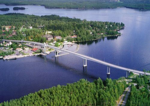
The main road route through the region is route 62, which connects to Mikkeli to the north and Imatra to the south.
Until the year 1995 a cable ferry connected the two sides of Puumalansalmi-strait. In 1995, a 781 metres (2,562 ft) long bridge replaced the ferry. The bridge is a very dominant structure when looking Puumala town center from a distance.
Puumala has relatively good services compared to the amount of population. In the town center is situated a post office, an Alko store, a kiosk, several supermarkets and a few restaurants. The reason for the survival of these entrepreneurs is the arrival of summer inhabitants who triple the population of Puumala during the season.
In history it is remembered for being the site of a staged attack on Swedish soldiers, by men wearing Russian military uniforms, but not actually serving in the Imperial Russian Army, on the 27th June 1788. This would allow Gustav III to declare a defensive war against the Russian Empire.
The puumala virus is named from here as it was first isolated from samples from the Puumala area.