
Type of site Photography website Alexa rank 82,585 | Available in English | |
 | ||
Owner Geograph Project Limited Slogan(s) Photograph every grid square! Website | ||
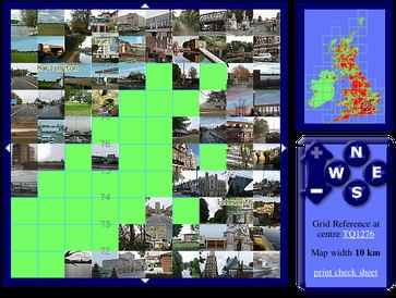
Geograph Britain and Ireland is a web-based project, initiated in March 2005, to create a freely accessible archive of geographically located photographs of Great Britain and Ireland. Photographs in the Geograph collection are chosen to illustrate significant or typical features of each 1 km × 1 km (100 ha) grid square in the Ordnance Survey National Grid and the Irish national grid reference system. There are 331,957 such grid squares containing at least some land (at low tide). Each page uses a Geo microformat.
Contents
- Contributions
- Types of image
- Statistics
- Photograph of the Year competition
- Awards
- Geograph Conference
- Tools and facilities
- Long term archival
- Sister projects
- References
Geographs are being collected for all parts of Great Britain and Ireland. The Channel Islands fall outside Britain's grid system, but may be geographed using their local UTM grid.
The project is sponsored by Ordnance Survey, and extracts from the OS Landranger 1:50,000 scale maps illustrate the grid square pages.
Geograph Project Limited, is a Charity Registered in England and Wales, and the name Geograph is trademarked.
Contributions
Photographs can be contributed by any registered user, although they must be approved by a panel of moderators before appearing on the website. The main aim of moderation is to make the site 'classroom ready' so that inappropriate images are rejected. The activity of taking photographs for the project is known as geographing. All images are licensed by the contributors using the Creative Commons cc-by-sa 2.0 licence which permits modification and redistribution of the images under certain conditions. Contributors should be aware that they are granting everyone an irrevocable licence to use their image(s); it is very difficult to get an image removed once it appears on the website. Photo resolution is a minimum of 640 by 480 pixels, with options for higher resolutions.
The entire archive of images with RDF metadata is being made available for download via BitTorrent.
As an incentive to increase coverage, participants are awarded a point each time they contribute the first photograph classified as a geograph to a grid square. There is, however, no limit to the number of images per square, and some squares have over 1000 images.
Some participants combine geographing with other outdoor location sports such as letterboxing, geocaching, trigpointing, benchmarking, and peak bagging.
Types of image
Geograph images are classified by site moderators as:
There is a special classification of image that is known as a First Geograph – the first image uploaded of a particular grid square which meets the requirements to be a geograph; this status is assigned automatically by the system and not by moderators. Later a new system of points, where contributors can gain Second, Third and Fourth points, was introduced. Similar to the first point system, this time a contributor gains a point depending on how many other geographers have submitted geographs to that square. For example, a square with one geograph by one contributor would have second, third and fourth points available. The same situation would apply if the first contributor has submitted many geographs in that square. The date the photo was taken makes no difference to the points system. So the next person to submit a geograph gains a second visit point. The third person to submit would get a third visit point and so on. This incentive was introduced after feedback from members as well as a need to fill up squares with few images.
In order to increase the date range of submitted photos per square a new TPoint or Time-gap Point incentive was later introduced. A contributor can gain a TPoint by submitting a contemporary photo to a square that has not had a photo for 5 years. A contributor can also gain a TPoint by submitting an historic photo to a square that was taken at least 5 years away from any other photograph in the square.
Some of the common themes for geograph photos include:
Statistics
As of 24 June 2014, the project had over 4 million photographs contributed by over 12,000 contributors, covering almost 97% of Great Britain and 40% of Ireland. There were an average of 14.8 images per grid square.
Milestones include:
Photograph of the Year competition
A weekly competition runs in the members-only forums to select the Photograph of the Year (POTY) from photographs taken that week. Each week one of a panel of volunteer selectors chooses around 50 of the week's best photos. Last week's winner then picks their favourite photo from the 50. After the end of the year the weekly winners are voted on to decide the best photo of each month and overall winner.
The annual winners were;
Awards
The Geograph site was awarded the Yahoo (UK & Ireland) Travel Find of the Year 2006.
UK Wikimedian of the Year 2012 – Honourable Mention
Geograph Conference
First Geograph Conference
On Wednesday 17 February 2010, Geograph British Isles organised its first conference for contributors to the project. About 80 contributors attended to discuss the project in both plenary and break-out sessions. The event was hosted by Geograph's sponsor, Ordnance Survey. It took place at the Ordnance Survey head office at Romsey near Southampton and was reported by geography-related media.
Second Geograph Conference
On Wednesday 4 April 2012 a second conference took place at The Circle in Sheffield. It took stock of where the project was at that time, as it neared 3 million submissions; and put forward potential solutions that could secure its financial future in the years ahead.
Third Geograph Conference
The third conference took place at The Edinburgh Training and Conference Venue on Saturday 8 June 2013. Subjects discussed included funding of the project, educational use of the images and the moderation procedures applied to contributors' submissions.
Fourth Geograph Conference
For the fourth conference the venue returned to Southampton and the Ordnance Survey's new headquarters building at Adanac Park on Friday 27 June 2014. Subjects discussed included the quality of submitted photographs and titles, the production of good quality descriptions, local studies, as well as the funding of the project, educational use of the images and the moderation procedures applied to contributors' submissions as in 2013.
Fifth Geograph Conference
For the fifth conference Geograph members gathered at Peterborough. On the Friday afternoon conference attendees visited a brickworks just outside the city. The conference itself was held at Peterborough Museum: this included a talk on the geologist William Smith. Walks around the city centre and local waterways concluded the proceedings.
Tools and facilities
The site has a number of tools for making use of the photographs. Collectively known as Collections , the site front page now features a Collection of the week. The various techniques include (with examples):
Contributors can choose to add meta-data to each image, in the form of Subject and Tags, to go along with the geo-tagging by location. All of this allows the use of a clever Browser to allow the relatively large archive to be searched. There are other methods of search, of course, ranging from Simple text search to tagged searches and complex searches.
Because of the geographic indexing of the pictures, it is possible to summons a page for an individual 1-km square. These square pages all provide a /link page which links to internal and external tools, such as a wide range of other mapping sites, and the various national historical artifacts databases. For the example given, these are things like DEFRA and Pastscape.
The site has a lot of detailed statistics, but can also create personal profile and personal coverage maps. It started as a game, and many of the tools support personal achievement and goals.
Long term archival
The site's 4 million plus photographs has been selected for long term web archiving by the British Library in their UK Web Archive.
Many photographs have been transferred to Wikimedia Commons, and the photos are used throughout thousands of Wikipedia articles. Although automatic blanket transfers have not occurred since about 1.8 million, tools and advice for transferring are provided for each photo on its re-use page.
Sister projects
In 2009, a sister project, Geograph Deutschland was launched, covering Germany. Geograph Ireland currently co-exists with Geograph British Isles, but may split into a separate project. Geograph Channel Islands covers the Channel Islands.