
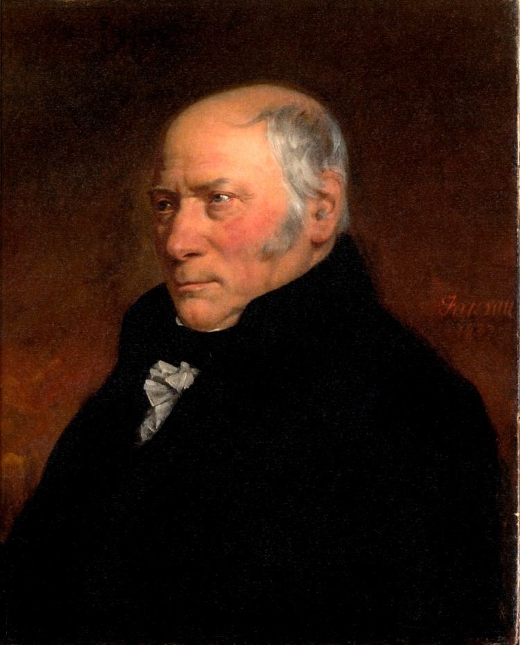
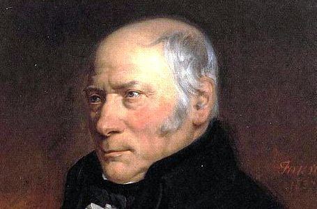
Nationality English | Role Geologist Name William Smith | |
 | ||
Born 23 March 1769Churchill, Oxfordshire ( 1769-03-23 ) Books A Memoir to the Map and Delineation of the Strata of England and Wales with Part of Scotland Similar People Simon Winchester, Adam Sedgwick, Alexandre Brongniart, Joseph Banks, Thomas Coke - 1st Earl of Le | ||
William smith an extraordinary life part 1
William 'Strata' Smith (23 March 1769 – 28 August 1839) was an English geologist, credited with creating the first nationwide geological map. At the time his map was first published he was overlooked by the scientific community; his relatively humble education and family connections prevented him from mixing easily in learned society. Consequently, his work was plagiarised; financially ruined, he spent time in debtors' prison. It was only much later in his life that Smith received recognition for his accomplishments, and became known as the "Father of English Geology".
Contents
- William smith an extraordinary life part 1
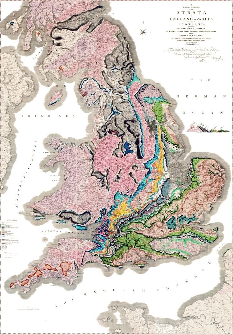
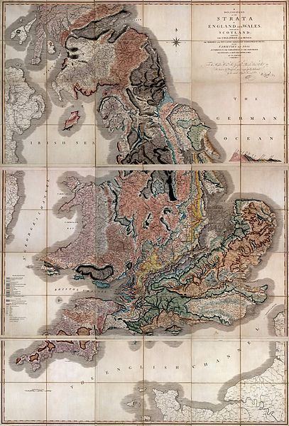
- Map that changed the world william smith strata map
- Early life
- Lifes work
- Publication and disappointment
- Later recognition
- Legacy
- References
Map that changed the world william smith strata map
Early life
Smith was born in the village of Churchill, Oxfordshire, the son of blacksmith John Smith, himself scion of a respectable farming family. His father died when Smith was just eight years old, and he was then raised by his uncle, also called William Smith. Although largely self-educated, Smith was highly intelligent and observant, read widely from an early age, and showed an aptitude for mathematics and drawing. In 1787, he met and found work as an assistant for Edward Webb of Stow-on-the-Wold, Gloucestershire, a surveyor. He was quick to learn, and soon became proficient at the trade. In 1791, he travelled to Somerset to make a valuation survey of the Sutton Court estate, and building on earlier work in the same area by John Strachey. He stayed in the area for the next eight years, working first for Webb and later for the Somersetshire Coal Canal Company, living at Rugborne Farm in High Littleton. During this period, Smith inspected a number of coal mines in the area, where he first observed and recorded the various layers of rock and coal exposed by the mining; Smith's coal mine studies, combined with his subsequent observations of the strata exposed by canal excavations, proved crucial to the formation of his theories of stratigraphy.
Life's work
Smith worked at one of the estate's older mines, the Mearns Pit at High Littleton, part of the Somerset coalfield and the Somerset Coal Canal. As he observed the rock layers (or strata) at the pit, he realised that they were arranged in a predictable pattern and that the various strata could always be found in the same relative positions. Additionally, each particular stratum could be identified by the fossils it contained, and the same succession of fossil groups from older to younger rocks could be found in many parts of England. Furthermore, he noticed an easterly dip of the beds of rock—low near the surface (about three degrees), then higher after the Triassic rocks. This gave Smith a testable hypothesis, which he termed The Principle of Faunal Succession, and he began his search to determine if the relationships between the strata and their characteristics were consistent throughout the country. During subsequent travels, first as a surveyor (appointed by noted engineer John Rennie) for the canal company until 1799 when he was dismissed, and later, he was continually taking samples and mapping the locations of the various strata, and displaying the vertical extent of the strata, and drawing cross-sections and tables of what he saw. This would earn him the name "Strata Smith". As a natural consequence, Smith amassed a large and valuable collection of fossils of the strata he had examined himself from exposures in canals, road and railway cuttings, quarries and escarpments across the country. He also developed methods for the identification of deposits of Fuller's earth to the south of Bath.
He published his findings with many pictures from his fossil collection, enabling others to investigate their distribution and test his theories. His collection is especially good on Jurassic fossils he collected from the Cornbrash, Kimmeridge clay, Oxford clay, Oolitic limestone and other horizons in the sequence. They included many types of brachiopods, ammonites and molluscs characteristic of the shallow seas in which they were deposited. Some of the names he coined (like Cornbrash) are still used today for this formation.
Publication and disappointment
In 1799 Smith produced the first large scale geologic map of the area around Bath, Somerset. Previously, he only knew how to draw the vertical extent of the rocks, but not how to display them horizontally. However, in the Somerset County Agricultural Society, he found a map showing the types of soils and vegetation around Bath and their geographical extent. Importantly, the differing types were coloured. Using this technique, Smith could draw a geological map from his observations showing the outcrops of the rocks. He took a few rock types, each with its own colour. Then he estimated the boundaries of each of the outcrops of rock, filled them in with colour and ended up with a crude geological map.
In 1801, he drew a rough sketch of what would become "The Map that Changed the World" (which inspired the book of that name). Smith travelled extensively across Britain working as a mineral surveyor allowing him to meet prominent people such as Thomas Coke, 1st Earl of Leicester, and the Duke of Bedford.
In 1815 he published the first geological map of Britain, based on a John Cary map. It covered the whole of England and Wales, and parts of Scotland. While this was not the world's first geological map (a map of the United States by William Maclure was published six years earlier), Smith's was the first geological map covering such a large area. Conventional symbols were used to mark canals, tunnels, tramways and roads, collieries, lead, copper and tin mines, together with salt and alum works. The various geological types were indicated by different colours, applied by hand. Nevertheless, the map is remarkably similar to modern geological maps of England. He published his Delineation of the Strata of England in the same year. In another of his books Strata Identified by Organized Fossils (London 1816-1819) he recognised that strata contained distinct fossil assemblages which could be used to match rocks across regions. In 1817 he drew a remarkable geological section from Snowdon to London.
Smith's various projects, starting with a mortgage taken to purchase his estate at Tucking Mill in Somerset in 1798, accrued financial commitments that ran into a series of difficulties which he managed to withstand by borrowing money from sympathetic creditors and mortgagors and funding repayments by taking on a relentless schedule of work commissions between 1801 and 1819. However a project to quarry Bath Stone near his property, for sale to the London property development market, failed to return the significant investment it had required due to poor quality stone and Smith found himself in default to co-investor Charles Conolly. Smith had used his Bath estate as security against Conolly's loan but there was excess to pay. In attempting to stave off his debt Smith sold his 'fossil collection' to the British Museum for £700, but this proved insufficient and funds fell short of the sum owed to Conolly by £300 and as a consequence Smith was sent to debtor's prison in 1819. Through all this financial turmoil, Smith managed to publish his map and subsequent associated publications but in 1817 he remarked "My income is as yet not anywise improved by what has been done, the profits being required to liquidate the debt incurred by publication."
On 31 August 1819 Smith was released from King's Bench Prison in London, a debtor's prison. He returned to his home of fourteen years at 15 Buckingham Street to find a bailiff at the door and his home and property seized. Smith then worked as an itinerant surveyor for many years until one of his employers, Sir John Johnstone, recognised him and took steps to gain for him the respect he deserved. Between 1824 and 1826 he lived and worked in Scarborough, and was responsible for the building of the Rotunda, a geological museum devoted to the Yorkshire coast. The Rotunda was re-opened as 'Rotunda – The William Smith Museum of Geology', on 9 May 2008 by Lord Oxburgh; however, the Prince of Wales visited the Rotunda as early as 14 September 2007 to view the progress of the refurbishment of this listed building.
Later recognition
It was not until February 1831 that the Geological Society of London conferred on Smith the first Wollaston Medal in recognition of his achievement. It was on this occasion that the President, Adam Sedgwick, referred to Smith as "the Father of English Geology". Smith travelled to Dublin with the British Association in 1835, and there unexpectedly received an honorary Doctorate of Laws (LL.D.) from Trinity College. In 1838 he was appointed as one of the commissioners to select building-stone for the new Palace of Westminster. He died in Northampton, and is buried a few feet from the west tower of St Peter's Church, Marefair. The inscription on the grave is badly worn but the name "William Smith" can just be seen. Subsequent modern geological maps have been based on Smith's original work, of which several copies have survived including one which has been put on display at the Geological Society of London.