
Website www.geo-wiki.org | ||
 | ||
Original author(s) | ||
Geo-wiki is a platform for engaging citizens in environmental monitoring. It aids in both the validation of existing geographical information and the collection of new geographical information through crowdsourcing. Using tools such as Google Earth, Bing Maps, Geotagged photographs and the internet, individual volunteers are able to contribute valuable information. It provides feedback on existing information overlaid on satellite imagery or by contributing entirely new data. Data can be input via the traditional desktop platform or mobile devices, with campaigns and games used to incentivize input. Resulting data are available without restriction.
Contents
Land cover validation
Global land cover validation exercises are feasible as images less than 2.5 meter resolution provide very detailed information on land cover with global coverage of at least 20% with more high-resolution, up to date images continuously being added. Internet tools such as Google Earth offer enormous potential for land cover validation. The use of Volunteer Geographic Information for land cover validation studies seems even more relevant as Google Earth has been used for the recent validation of remote sensing derived products e.g., the European forest cover map as well as the latest global land cover map GlobCover. Google Earth allows wider audience to be involved in a validation exercise.
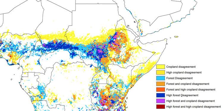
Applications of Geo-wiki go beyond simply improving land cover. An application helps to predict future deforestation in Central Africa, combining five existing cropland data sets from sub-Saharan Africa to create a new map which has higher accuracy than existing maps. This should reduce uncertainty and improve predictions in land use, vegetation, climate change, and earth systems modeling. Scientists from several research institutions describe development of the map in Geophysical Research Letters, along with the application of Geo-Wiki.