
Prominence 975 Elevation 2,332 m | Mountain range Carnic Alps | |
 | ||
Similar Mölltaler Polinik, Findenigkofel, Pal Piccolo, Creta di Timau, Trogkofel | ||
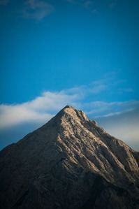
The Gailtaler Polinik (also known as the Angerkofel) is a mountain, 2,332 m (AA), in the Carnic Alps in the Austrian state of Carinthia. It lies on the main ridge of the Carnics and is the highest peak of the Eastern group.
Map of Gailtaler Polinik, 9640, Austria
It lies south of the market municipality of Kötschach-Mauthen and northeast of the Plöcken Pass. The easiest and shortest climb runs from the Plöckenhaus via the Spielbodenalm and Spielbodentörl to the summit of the Polinik. Its free-standing situation offers a very impressive panoramic view of the upper Gail valley and the Gailtal Alps.
References
Gailtaler Polinik Wikipedia(Text) CC BY-SA