
Topo map USGS Mount Johnson | Elevation 1,053 m Country United States of America | |
 | ||
Similar Fremont Peak, Pinnacles National Park, Fremont Peak State Park, California Coast Ranges, Temblor Range | ||
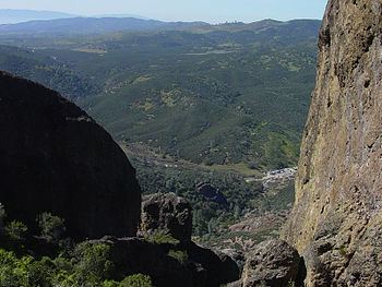
The Gabilan Range or Gabilan Mountains are a mountain range in the Southern Inner California Coast Ranges System, located in Monterey County and San Benito County of central California. Pinnacles National Park is located in the southern section of the range.
Contents
Map of Gabilan Range, California 95043, USA
GeographyEdit
The Gabilan Range trends in a northwest-southeast direction along the Monterey County and San Benito County line. It is bordered on the east by the Diablo Range, the San Andreas Fault, and State Route 25; and on the west by the Salinas Valley, Santa Lucia Range, and U.S. Route 101.
Fremont Peak, at 3,455 feet (1,053 m) in elevation, is the range's highest point. There are several other peaks also over 3,000 feet (910 m) in the range.
HistoryEdit
In Spanish, gavilan (gabilan is an older alternate rendering) means "sparrow hawk". Hawks, especially the red-tailed hawk, are common in the range.
The Gabilan Mountains and other nearby places are mentioned in several novels by John Steinbeck, such as Of Mice and Men and East of Eden. In The Red Pony notably, the main character (Jody Tiflin) names his pony "Gabilan" after the mountain range.