
Population 11,489 (2013) | Area 10.83 km² | |
 | ||
Restaurants Zanklstüb, Göstinger Hof, Gasthaus Zur Sonne, Chinarest Zum * STERN, McDonal & McDrive | ||
Burgruine g sting g sting castle
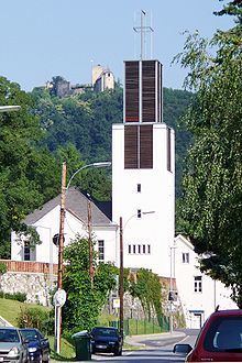
Gösting (from Slavic gostinca = hostel, or gozd = mountain forest) is the 13th city district of Graz, in the Austrian province of Styria. It is situated in the north-west of the city between the river Mur and the Plabutsch mountain and the range north of it on which the ruined Gösting Castle is located.
Contents
- Burgruine g sting g sting castle
- Map of GC3B6sting Graz Austria
- History
- Buildings
- Economy schools and traffic
- References
Map of G%C3%B6sting, Graz, Austria
History
Before the year 1138 the village and the castle were founded by the Aribon Swiker von Gösting. About 1430 the village contained 33 farms and several craftsmen among which were two millers in the still today called miller's quarter (Müllerviertel) and am Thalbach stream.
In 1707 the castle and the fiefdom (Herrschaft) were bought by the Counts of Attems. In the 18th century the castle fell more and more into disrepair after a fire caused by a lightning strike in 1723 destroyed it almost completely.
From 1850 until 1938 Gösting was a community of its own that was governed by its community leaders and since 1919 by its mayors. Some street names still bear their names, for example Franz Weixelbaum or Josef Pock. In 1931 Gösting got the market right and in 1938 became a part of Graz. Since 1946 it has been the 13th city district of the Styrian capital Graz. To the district also belongs the settlement Raach which is located further north and which developed during the 1940s on former pasture land.