
- elevation 12,083 ft (3,683 m) - elevation 6,591 ft (2,009 m) Basin area 613.8 km² | Length 68 km Source Sawatch Range | |
 | ||
- left Marten Creek, South Fork Fryingpan River, Rocky Fork Creek - right Ivanhoe Creek, North Fork Fryingpan River, Lime Creek - location Hunter-Fryingpan Wilderness, Pitkin County | ||
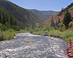
The Fryingpan River is a tributary of the Roaring Fork River, approximately 42 miles (68 km) long, in west central Colorado in the United States.
Contents
Map of Fryingpan River, Colorado, USA
HistoryEdit
The reason for the unusual name of the river is that when a group of trappers were attacked by a band of Ute Indians, only two men survived, one of whom was injured. Leaving his wounded friend in a cave close by, the last man left to summon help, but not before hanging a frying pan in a tree so that he could find the cave again on his return.
GeographyEdit
It rises in northeastern Pitkin County, in the White River National Forest in the Sawatch Mountains along the western side of the continental divide. It flows westward along the county line between Pitkin and Eagle County. Below Meredith, it is dammed to form the Ruedi Reservoir. It joins the Roaring Fork below Basalt. A portion of the river's water is diverted to the east side of the continental divide for irrigation and drinking water via the Fryingpan-Arkansas Project.