
Population 13,192 (2011 census) Area 9.1 km² | Postcode(s) 2086 Postal code 2086 | |
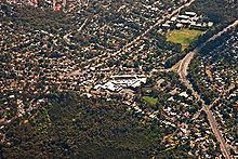 | ||
Frenchs Forest is a suburb of northern Sydney, in the state of New South Wales, Australia. Frenchs Forest is 13 kilometres north of the Sydney central business district in the local government area of Northern Beaches Council. Frenchs Forest is part of Sydney's Northern Beaches region and also considered to be part of the Forest District, colloquially known as The Forest.
Contents
- Map of Frenchs Forest NSW 2086 Australia
- Aboriginal culture
- European settlement
- Geography
- Climate
- Commercial areas
- Schools
- Churches
- Road
- Buses
- Culture
- Events
- Clubs
- Sport and recreation
- Population
- References
Map of Frenchs Forest NSW 2086, Australia
The suburb is currently going through rezoning which will include a new hospital, town centre, new relocated high school, 2,200 new homes and $500 million to upgrade the roads around the new Northern Beaches Hospital.
The rezoning is proposed to be completed in time for the hospital opening in 2018.
Aboriginal culture
Prior to the arrival of the First Fleet in Port Jackson in 1788, the area of land we now know as Frenchs Forest, and surrounding Warringah areas, was the home of the Guringai (Ku-ring-gai) language group of the Garigal Aboriginal clan. Evidence of their habitation remains today in the form of rock engravings, rock art, open campsites, rock shelters, scarred trees and middens. The word Warringah has many interpretations including "sign of rain", "across the waves" and "sea".
European settlement
European exploration into Warringah began within the first weeks of settlement at Sydney Cove in 1788. Governor Phillip made a number of journeys throughout the area, detailing the landscape, flora and fauna, as well as observing Aboriginal lifestyle and culture. Although Beacon Hill advertises the "Arthur Phillip lookout" at its peak, it is believed by some historians that Phillip's travels actually took him through Bantry Bay and up into Frenchs Forest to gain views over the area.
In 1853 Simeon Henry Pearce (1821–1886) and his brother James acquired 200 acres (0.81 km2) in this area. The property was later known as Rodborough when it was acquired by James French, a police constable, who also developed the land that became neighbouring Forestville. Despite its relative proximity to Sydney, Frenchs Forest remained predominantly rural throughout the nineteenth century.
Geography
Frenchs Forest is close to the Garigal National Park. It is elevated (~156 m ASL) regularly having high rainfall compared with the rest of Sydney and is spread along ridgelines surrounded by native bushland. The eastern parts have distant views (3 km) over the Pacific Ocean and the temperature extremes typical of Sydney are moderated by this proximity. Garigal National Park features native wildlife, birds, turtles, wallabies, lizards, snakes. Bush tracks include bluff track and natural bridge track.
Climate
Commercial areas
Forestway Shopping Centre is at the intersection of Forestway and Warringah Road. The centre includes an Aldi and Woolworths supermarkets and over 50 speciality stores.
Smaller shopping centres are located at Sorlie Road featuring a variety of restaurants and Skyline shops on Frenchs Forest Road East, the name being derived from the 'Skyline Drive-in Movie Theatre' that existed nearby until the mid-1980s.
Schools
Frenchs Forest is home to a number of schools:
Churches
Although named Frenchs Forest Catholic Parish, the three church buildings that make up the parish are located in the adjoining suburbs of Davidson, Forestville & Terrey Hills.
Road
The main Routes through Frenchs Forest include the east-west Warringah Road (State route A38), connecting Roseville in the west with Brookvale in the east; the north-south Forestway, starting at Warringah Road in Frenchs Forest and heading north through Belrose to Terrey Hills (8 km); the north-south Wakehurst Parkway (State route 22), starting at Narrabeen in the northeast, crossing Warringah Road in Frenchs Forest, and heading south to Seaforth. Following any of these three major roads lead to the only three road routes off the Warringah peninsula.
The intersection of Wakehurst Parkway and Warringah Road was the scene of multiple high speed collisions when these two roads were dirt tracks through the bush. To improve this, a blinking light was suspended above the intersection in the first half of the 20th century to warn motorists of the danger, which earned the interesting the enduring name of 'The Blinking Lights'.
Buses
Forest Coach Lines connects Frenchs Forest with Chatswood railway station in the west, Warringah Mall shopping centre at Brookvale in the east and Terrey Hills in the north. An express City bus service to Town Hall railway station in the Sydney CBD.
Culture
Events
Clubs
Sport and recreation
Population
In the 2011 census of Population and Housing, the population of the Frenchs Forest postcode area was 13,192 people. The population was 50.1% females, 49.9% males. In Frenchs Forest, 29.4% of people were born outside of Australia. The top religious affiliations in the area were in descending order: Catholic, Anglican, No religion, Uniting Church, and Presbyterian and Reformed. The three most common forms of dwelling were in decreasing order: separate house (4,035), semi-detached, row or terrace house, or townhouse (96) and flat, unit or apartment (32).