
Population 6,726 (2011 census) Postcode(s) 2092 Area 3.1 km² Postal code 2092 | Established 1906 Founded 1906 | |
 | ||
LGA(s) | ||
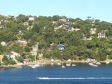
Seaforth is a suburb of northern Sydney, in the state of New South Wales, Australia. Seaforth is located 12 kilometres north-east of the Sydney central business district in the local government area of Northern Beaches Council and is part of the Northern Beaches region.
Contents
Map of Seaforth NSW 2092, Australia
Seaforth overlooks Middle Harbour and is linked south to Mosman by the Spit Bridge. To the west, Seaforth overlooks Sugarloaf Bay across to the suburbs of Northbridge, Castlecrag and Castle Cove. The Garigal National Park sits on the northern border.
History
Seaforth was named after Loch Seaforth and Seaforth Island in Scotland. The land in this area was once owned by Henry Halloran, who subdivided it in 1906.
The Seaforth library was built in 1887 and protected by heritage listing by Manly Council in 1995. It stands outside the former Seaforth TAFE. Seaforth celebrated its centenary on Sunday 12 November 2006 with a historical display in the town centre.
Commercial area
The Seaforth shopping district is located off Sydney Road and offers a wide variety of services, including niche market products. It is also home to Balgowlah RSL Memorial Club.
Demographics
At the 2011 census, the suburb of Seaforth recorded a population of 6,726. Of these:
Schools
Seaforth is home to Seaforth Public School and Balgowlah Boys High School. There is currently an aged care facility in construction where a TAFE used to be. It was demolished in 1999. The site has since been the subject of controversial redevelopment plans, though most have been postponed. One such plan is to "transform Seaforth into a structured town centre with shops, cafes, offices, flats and civic space."