
Population 125 (2006 census) Postcode(s) 5690 LGA(s) unincorporated area Postal code 5690 | Established 1890 Time zone ACST (UTC+9:30) Elevation 3 m Local time Thursday 5:34 AM | |
 | ||
Location 658 km (409 mi) NW of Adelaide city centre500 km (311 mi) W of Port Augusta118 km (73 mi) W of Ceduna Weather 18°C, Wind S at 21 km/h, 70% Humidity | ||
Fowlers Bay, formerly Yalata, is a small coastal town in the Australian state of South Australia located about 658 kilometres (409 mi) north-west of the state capital, Adelaide. Situated on the Nullarbor Plain, it was once an active port and a gateway to the western reaches of the continent, but fell into decline in the 1960s. At the 2006 census, Fowlers Bay and the surrounding area had a population of 125.
Contents
- Map of Fowlers Bay SA 5690 Australia
- European exploration
- Settlement
- Heritage listings
- In the 2000s
- Governance
- Climate
- References
Map of Fowlers Bay SA 5690, Australia
European exploration
The coastline around Fowlers Bay was first mapped in 1627 by François Thijssen, a Dutch sea captain. His ship was the Golden Seahorse (Gulden Zeepard). Fowlers Bay was named on 28 January 1802 by Matthew Flinders after his first lieutenant, Robert Fowler.
Edward John Eyre set up base camp here in 1840 during his epic journeys across the Nullarbor Plain. By this time the area was well-known to American and French whaling ships; Eyre documents seeing whalers in the area.
Settlement
In the 1860s, the first pastoral leases were established by William Swan and Robert Barr Smith, forming Yalata station, a farming property whose boundaries extended from the Head of the Bight in the west to Streaky Bay in the east.
The settlement was surveyed in March 1890 and proclaimed a town (under the name Yalata) in the Government Gazette in 1890, with the name being changed to Fowler's Bay in 1940. The settlement is on Port Eyre at the western end of the larger Fowlers Bay. Yalata now refers to a nearby township.
Heritage listings
Fowlers Bay contains one place listed on the South Australian Heritage Register - Whale Bone Area and the Point Fowler Structure.
In the 2000s
Today Fowlers Bay is located in the unincorporated area of South Australia (only 15% of the state is under Local Government). The town does not receive reticulated power or water. It is currently a popular overnight destination between Nundroo and Penong, and its fishing facilities, beaches and surrounding historical ruins gives the town some interest for tourists and sightseers. There are no sealed roads to Fowlers Bay and visitors should seek advice before driving across the saltwater bog behind the town.
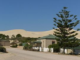
Visually the town is dominated by a large sand dune that protects the town from the Southern Ocean. Southern right whales have recolonised into the area in recent years, with the bay providing a small but ideal sanctuary. Bottlenose dolphins and Australian sea lions may also be found.
The ruins of the homestead of the Yalata station can be found several kilometres from the town. There is a small cemetery on the outskirts of the town.
Governance
Fowlers Bay is located within the federal Division of Grey, the state electoral district of Flinders and the unincorporated area of South Australia. In the absence of a local government authority, the community in Fowlers Bay receives municipal services from a state government agency, the Outback Communities Authority.
Climate
Fowler Bay has semi arid climate, which has influences of Great Australian Bight. The highest recorded temperature was +48,4 and the lowest recorded was -3.2 degrees.