
Listing Ultra Elevation 3,359 m Prominence 1,951 m | First ascent 2 February 1952 Mountain range Andes | |
 | ||
Similar Cerro Torre, Torre Egger, Cerro Catedral, Aguja Saint Exupery, Aconcagua | ||
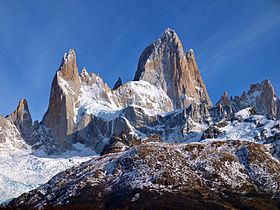
Monte Fitz Roy (also known as Cerro Chaltén, Cerro Fitz Roy, or simply Mount Fitz Roy) is a mountain located near El Chaltén village, in the Southern Patagonian Ice Field in Patagonia, on the border between Argentina and Chile. First climbed in 1952 by French alpinists Lionel Terray and Guido Magnone, it remains among the most technically challenging mountains for mountaineers on Earth.
Contents
- Map of Fitz Roy
- Fitz roy los glaciares national park santa cruz province patagonia argentina south america
- Discovery
- Setting
- Notable ascents
- References
Map of Fitz Roy
Monte Fitz Roy is the basis for the Patagonia clothing logo following Yvon Chouinard's ascent and subsequent film in 1968.
Fitz roy los glaciares national park santa cruz province patagonia argentina south america
Discovery
Argentine explorer Francisco Moreno first saw the mountain on 2 March 1877. He named it Fitz Roy, in honour of Robert FitzRoy, who, as captain of the HMS Beagle had travelled up the Santa Cruz River in 1834 and charted large parts of the Patagonian coast.
Cerro is a Spanish word meaning hill, while Chaltén comes from a Tehuelche (Aonikenk) word meaning "smoking mountain", due to a cloud that usually forms around the mountain's peak. Fitz Roy, however, was only one of a number of peaks the Tehuelche called Chaltén.
Setting
It has been agreed by Argentina and Chile that their international border detours eastwards to pass over the main summit, but a large part of the border to the south of the summit, as far as Cerro Murallón, remains undefined. The mountain is the symbol of the Argentine Santa Cruz Province, which includes its representation on its coat of arms.