
Top elevation 2100 Longest run 9 km Province Río Negro Province Nearest city Bariloche | Base elevation 1030 Elevation 2,405 m Mountain range Andes | |
 | ||
Location Rio Negro, Patagonia, Argentina Skiable area 600 hectares (1,500 acres) Runs 31 - 120 kilometres (75 mi) Green - 4 Blue - 11 Red - 12 Black - 5 Similar Tronador, Chapelco, Cerro Bayo, Fitz Roy, Lanín | ||
Cerro Catedral is a mountain located 19 kilometres (12 mi) from San Carlos de Bariloche, and inside the Nahuel Huapí National Park, Patagonia, Argentina.
Contents
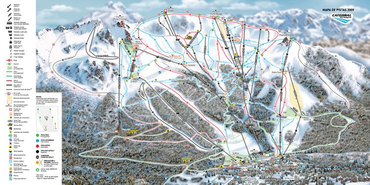
Map of Cerro Catedral, R%C3%ADo Negro, Argentina
The mountain holds one of the biggest ski centers in South America, with a skiable area of 6 km2 (2.3 sq mi), 120 km (75 mi) of ski runs, and a lift capacity of 35,000 skiers per hour. It is also very popular due to the magnificent view of the Nahuel Huapi lake. There are also a number of hotels and hostels at the foot of the mountain, and a summer hikers' hut called Refugio Lynch on one of the tops of the mountain.
During the summer, the Refugio Frey and a camping accommodate trekkers and rock climbers next to Tonček lagoon, near the Torre Principal; Catedral's highest point.
On August 27, 2005, the 1st South American Ski Mountaineering Championship in combination with the last race of the 2005 South American Ski Mountaineering Cup and the 2nd International Open of ski mountaineering was carried out on the Cerro Catedral.
Climate
The climate is affected by the altitude. At higher elevations, at the weather station, the climate is classified as an alpine climate or a tundra climate (Köppen ET) while at lower elevations, the climate is classified as a cool mediterranean climate (Köppen: Csb). Cerro Catedral has the highest frequency of days with snowfalls in Argentina, averaging 98 days per year.