
Isolation 30.98 mi (49.86 km) Elevation 2,936 m | Easiest route hike Prominence 563 m | |
 | ||
Parent range Highest summit of Raton Mesa Topo map USGS 7.5' topographic mapFishers Peak, Colorado Similar West Spanish Peak, East Spanish Peak, Culebra Peak, Greenhorn Mountain, Parkview Mountain | ||
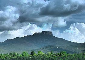
Fishers Peak is the highest summit of Raton Mesa in the Rocky Mountains of North America. The prominent 9,633-foot (2,936 m) peak is located 5.5 miles (8.8 km) south by east (bearing 163°) of the Town of Trinidad in Las Animas County, Colorado, United States. Fishers Peak is higher than any point in the United States east of its longitude.
Map of Fishers Peak, Colorado 81082, USA
References
Fishers Peak Wikipedia(Text) CC BY-SA