
- location near White Rock | - elevation 1,160 m (3,806 ft) - elevation 668 m (2,192 ft) | |
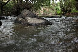 | ||
Fish River, a perennial stream that is part of the Macquarie catchment within the Murray–Darling basin, is located in the central western district of New South Wales, Australia.
Map of Fish River, New South Wales, Australia
The Fish River rises on the plateau south east of Oberon, and flows generally to the north-west, becoming the main headwater of the Macquarie River just east of Bathurst. The river is impounded by a reservoir near Oberon which supplies water for the region. The Fish River descends 493 metres (1,617 ft) over its 119 kilometres (74 mi) course.
The Fish River was given its name by George Evans in 1813, because of the large number of fish they found in it, being a rare permanent stream.
References
Fish River (Oberon) Wikipedia(Text) CC BY-SA