
- right Wisemans Creek - elevation 1,180 m (3,871 ft) - elevation 706 m (2,316 ft) | - location near Black Springs - location near Bathurst Mouth Fish River | |
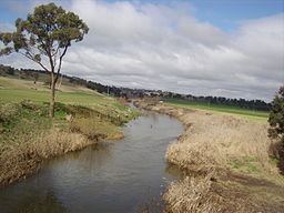 | ||
Campbells River, a perennial stream that is part of the Upper Macquarie catchment within the Murray–Darling basin, is located in the central–western region of New South Wales, Australia.
Map of Campbells River, New South Wales, Australia
The river rises on the western slopes of the Great Dividing Range about 6.4 kilometres (4.0 mi) south of Black Springs. It flows generally north by west, joined by one tributary, the Wisemans Creek, towards its confluence with the Fish River 9 kilometres (5.6 mi) south–south–east of Bathurst to become the Macquarie River; descending 473 metres (1,552 ft) over its 82 kilometres (51 mi) course.
The river is impounded by Ben Chifley Dam upstream of Bathurst and carries water released from the dam for Bathurst's potable water supply.
References
Campbells River Wikipedia(Text) CC BY-SA