
Area 22.64 km² Population 491 (2000) | Elevation 91 cm Area code 631 | |
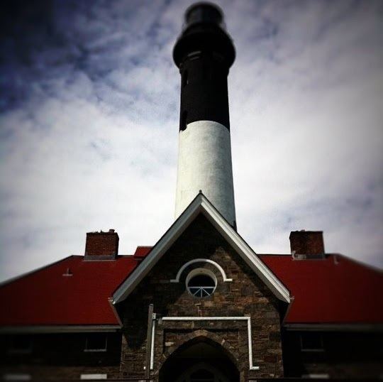 | ||
Points of interest Fire Island National Seashore, Fire Island Lighthouse, Robert Moses State Park, Smith Point County Park, Dunewood - New York | ||
Fire island pines cherry grove boardwalks
Fire Island is the large center island of the outer barrier islands parallel to the south shore of Long Island, New York. In 2012, Hurricane Sandy once again divided Fire Island into two islands. Together, these two islands are approximately 31 miles (50 km) long and vary between 520 and 1,310 feet (160 and 400 m) wide. Fire Island is part of Suffolk County. It lies within the towns of Babylon, Islip, and Brookhaven, containing two villages and a number of hamlets. All parts of the island not within village limits are part of the Fire Island census-designated place (CDP), which had a permanent population of 292 at the 2010 census, though that expands to thousands of residents and tourists during the summer months.
Contents
- Fire island pines cherry grove boardwalks
- Map of Fire Island NY USA
- Nyc to long island s south shore and hamptons plus fire island
- GeographyEdit
- Historical modificationsEdit
- EtymologyEdit
- SettlementEdit
- 2009 Beach renourishmentEdit
- 2012 Hurricane SandyEdit
- Landmarks and preservesEdit
- LocationsEdit
- Town of BabylonEdit
- Town of IslipEdit
- Town of BrookhavenEdit
- Other small islands around Fire IslandEdit
- Other locationsEdit
- InhabitantsEdit
- DemographicsEdit
- Famous summer residentsEdit
- Emergency servicesEdit
- In popular cultureEdit
- References
Map of Fire Island, NY, USA
The land area of Fire Island is 9.6 square miles (24.9 square kilometres).
Nyc to long island s south shore and hamptons plus fire island
GeographyEdit
Fire Island lies an average of 3.9 miles (6.2 kilometres) off the south shore of Long Island, but nearly touches it along the east end. It is separated from Long Island by Great South Bay, which spans interconnected bays along Long Island: Patchogue Bay, Bellport Bay, Narrow Bay, and Moriches Bay. The island is accessible by automobile near each end: via Robert Moses Causeway on its western end, and by William Floyd Parkway (Suffolk County Road 46) near its eastern end. Cross-bay ferries connect to over 10 points in between. Motor vehicles are not permitted on the rest of the island, except for utility, construction and emergency access and with limited beach-driving permits in winter. The island and its resort towns are accessible by boat, seaplane and a number of ferries, which depart from Bay Shore (Fire Island Ferries), Sayville, and Patchogue.
Fire Island is located at 40°39'35" north, 73°5'23" west (40.653°N 73.126°W / 40.653; -73.126). According to the United States Census Bureau, Fire Island has a land area of 9.6 square miles (24.9 km2).
Historical modificationsEdit
The physical attributes of the island have changed over time and they continue to change. At one point it stretched more than 60 miles (97 km) from Jones Beach Island to Southampton.
Around 1683, Fire Island Inlet broke through, separating it from Jones Beach Island.
The Fire Island Inlet grew to 9 miles (14 km) in width before receding. The Fire Island Lighthouse was built in 1858, right on the inlet, but Fire Island's western terminus at Democrat Point has steadily moved west so that the lighthouse today is 6 miles (10 km) from the inlet.
Fire Island separated from Southampton in a 1931 Nor'easter when Moriches Inlet broke through. However, this was expected. The inlet widened on September 21, 1938. Moriches Inlet and efforts by local communities east of Fire Island to protect their beach front with jetties have led to an interruption in the longshore drift of sand going from east to west and is blamed for erosion of the Fire Island beachfront. Between these major breaks there have been reports over the years of at least six inlets that broke through the island but have since disappeared.
EtymologyEdit
The origin of Fire Island's name is not certain. It is believed its Native American name was Sictem Hackey, which translated to "Land of the Secatogues". The Secatogues were a tribe in the area of the current town of Islip. It was part of what was also called the "Seal Islands".
The name of Fire Island first appeared on a deed in 1789.
Historian Richard Bayles suggested that the name derives from a misinterpretation or corruption of the Dutch word vijf ("five"), or in another version vier ("four"), referring to the number of islands near the Fire Island inlet. At times histories have referred to it in the plural, as "Fire Islands", because of the inlet breaks.
Other versions say the island derived its name from fires built on the sea's edge by Native Americans or by pirates to lure unsuspecting ships into the sandbars. Some say it is how portions of the island look to be on fire from sea in autumn. Yet another version says it comes from the rash caused by poison ivy on the island.
While the western portion of the island was referred to as Fire Island for many years, the eastern portion was referred to as Great South Beach until 1920, when widespread development caused the whole land mass to be called Fire Island.
SettlementEdit
William "Tangier" Smith held title to the entire island in the 17th century, under a royal patent from Thomas Dongan. The remnants of Smith's Manor of St. George are open to the public in Shirley, New York.
2009: Beach renourishmentEdit
A 2009 beach renourishment program was credited with saving the island from the full effects of Hurricane Sandy in 2012.
In the winter and spring of 2009, a beach renourishment project was undertaken on Fire Island, with the cooperation of the National Park Service, the U.S. Army Corps of Engineers, the Towns of Brookhaven and Islip, and Fire Island residents. The renourishment program involved dredging sand from an offshore borrow area, pumping it onto the beach and shaping the sand into an approved beach face and dune template in front of the communities of Corneille Estates, Davis Park, Dunewood, Fair Harbor, Fire Island Pines, Fire Island Summer Club, Lonelyville, Ocean Bay Park, Ocean Beach, Saltaire, and Seaview. Fire Islanders agreed to a significant property tax increase to help pay for the project, which was estimated to cost between $23 and $25 million ($6,020 per housing unit), including the cost of environmental monitoring, and was expected to add 1,400,000 cubic meters (1,800,000 cubic yards) of sand in front of the participating communities. The Towns of Brookhaven and Islip, in which the communities are located, issued bonds to pay for the project, backed by the new taxes levied by community Erosion Control Taxing Districts.
2012: Hurricane SandyEdit
The island was heavily damaged in the high tides associated with Hurricane Sandy in 2012 including three breaches around Smith Point County Park on the sparsely populated east end of the island. The biggest breach (and politically most difficult one to deal with because it is in a wilderness area) is at Old Inlet in the Otis Pike Wilderness Area just west of Smith Point County Park. Old Inlet is at the site of previous breaches (which have come and gone on their own) was 108 feet wide after the storm on the south end and 1,171 feet on February 28, 2013. Officials have been debating whether to close the breach and let nature take its course as it has been flushing out the Great South Bay and improving water quality. However residents of the bay front communities noted increased flooding after the storm. This flooding was later found to be the result of several nor'easters and unrelated to the breaches. As of 2015, the breach remained open. Officials have moved to close the other two breaches which are on either side of Moriches Inlet—one in Cupsogue County Park and the other one being in Smith Point County Park.
Reports indicated that 80 percent of the homes particularly those on the east end were flooded and 90 homes were completely destroyed. The storm also tore away about 75 feet of the dune coastline. But Fire Island was not hit as hard as other areas and most of the 4,500 homes on the island survived even if damaged. Officials credited the dune replenishment program with helping to spare the island.
Landmarks and preservesEdit
Except for the western 4 1⁄2 miles (7.2 km) of the island, the island is protected as part of Fire Island National Seashore. Robert Moses State Park, occupying the remaining western portion of the island, is one of the popular recreational destinations in the New York City area. The Fire Island Lighthouse stands just east of Robert Moses State Park.
A memorial to TWA 800 is located on the eastern end at Smith Point County Park near where the airplane crashed at sea.
LocationsEdit
Following are the locations on the island. Townships and communities are listed from west to east.
Town of BabylonEdit
Town of IslipEdit
Town of BrookhavenEdit
Other small islands around Fire IslandEdit
The following are associated islands in the Fire Island National Seashore Jurisdiction, from west to east:
Other locationsEdit
InhabitantsEdit
Fire Island's population varies seasonally. There are few residents in winter months, with the population rising in the late spring to early fall.
Housing is mostly stick-built bungalow-style with generous helpings of bamboo. Some are beachfront, built on the dunes of the Atlantic Ocean, while others are on boardwalks or concrete walks, like a miniaturized city. For year-round residents, there are schools, churches, shops and even a school bus service to Long Island via an off-road modified school bus.
The quiet villages on Fire Island provide solitude, while the larger towns like Ocean Beach and Cherry Grove provide a more social atmosphere with clubs, bars and open air dining. Two of these hamlets, Fire Island Pines and Cherry Grove, are destinations for LGBT vacationers.
The incorporated villages of Ocean Beach and Saltaire within Fire Island National Seashore are car-free during the summer tourist season (Memorial Day through Labor Day) and permit only pedestrian and bicycle traffic (during certain hours only in Ocean Beach). For off-season use, there are a limited number of driving permits for year-round residents and contractors. The hamlet of Davis Park allows no vehicles or bicycles year-round.
DemographicsEdit
As of the census of 2000, there were 491 people, 138 households, and 77 families residing on Fire Island. The population density was 52.82/mi2 (21.82/km2). There were 4,153 housing units, at an average density of 478.1/mi2 (184.6/km2). The racial makeup of the town was 96.77% White, 0.65% Asian, 0.32% Pacific Islander, 0.65% from other races, and 1.61% from two or more races. Hispanic or Latino of any race were 2.90% of the population.
There were 138 households on Fire Island, out of which 25.4% had children under the age of 18 living with them, 48.6% were married couples living together, 2.2% had a female householder with no husband present, and 44.2% were non-families. 34.8% of all households were made up of individuals and 10.1% had someone living alone who was 65 years of age or older. The average household size was 2.20 and the average family size was 2.90.
Fire Island's population was spread out with 20.6% under the age of 18, 6.5% from 18 to 24, 29.0% from 25 to 44, 33.5% from 45 to 64, and 10.3% who were 65 years of age or older. The median age was 42 years. For every 100 females there were 133.1 males. For every 100 females age 18 and over, there were 143.6 males.
The median income for a household on Fire Island was $73,281, and the median income for a family was $83,672. Males had a median income of $46,875 versus $41,429 for females. The per capita income for Fire Island was $43,681. 0.0% of families and 3.1% of individuals were below the poverty line, including 0.0% of those under age 18 and 8.6% of those age 65 or over.
Famous summer residentsEdit
After the Manhattan theater community began staying on Fire Island during the 1920s, the island had numerous summer celebrity residents.
Emergency servicesEdit
Fire Island's unique location and constantly changing geography play a major role in the protection of its citizens. Although it is served by nine fire departments and two police departments, the seasonal residency and remote driving distance are a challenge to the public safety community. Because there are no roads on inhabited Fire Island, fire department vehicles are heavily modified four-wheel drive with suspension lifts, large diameter off-road tires and recovery equipment, which allow them to traverse the sometimes washed-out, loose sand.
Until 1986, there was no ambulance service on Fire Island, prompting the village of Saltaire to form its rescue company, later followed by Ocean Beach, and then in 2004 with Fair Harbor. Due to relatively close distances, fire departments on Fire Island are obliged to provide mutual aid to neighboring communities. Some coastal fire departments on Long Island have fully equipped marine rescue and fire boat units which can cross the Great South Bay to provide necessary assistance.
Fire Island's corps of off-road-capable fire apparatus and the firefighters' training to use them effectively provide much-needed support in the event of a wildfire, as was illustrated in the Long Island Central Pine Barrens fires of 1995.
North Shore-LIJ Health System recently opened two urgent care facilities on Fire Island (one in Ocean Beach and the other in Cherry Grove). These centers operate during the summer from Memorial Day through Labor Day, and are open for walk-in patient visits seven days a week from 9 to 11 AM and 4 to 6 PM. If patients require medical treatment outside of those hours, the Immediate Care Center’s physician can be reached on call by contacting local police.
Good Samaritan Hospital Medical Center, Southside Hospital, and Brookhaven Memorial Hospital Medical Center are located directly across the Great South Bay from Fire Island in the Long Island hamlets of West Islip, Bay Shore, and the village of Patchogue, respectively. A heliport for medevac helicopter use is adjacent to Good Samaritan Hospital Medical Center. Specially equipped boats provided by the Suffolk County Police Department Marine Bureau docked at the various communities on Fire Island provide emergency transportation to individuals in need of dire medical care. In many cases, Long Island based ambulances will meet the boats once they cross the Bay (roughly 4.5 miles) and then drive individuals the short distance to one of the three hospitals.
The Suffolk County Police Department Marine Bureau is the primary law enforcement agency. Ocean Beach also has a dedicated police department of its own. Criminal proceedings are handled by Suffolk District Court and subjects that are arrested will go to the 3rd, 1st or 5th precinct, or to one of the Suffolk County Sheriff's Office-run jails. Small claims and property matters are usually handled by the individual village of case origin. It is common practice for police to write tickets then send unruly visitors off the island via water taxi, at the offender's expense.
The Suffolk County Park Police and New York State Park Police patrol the Robert Moses State Park, while the National Park Service is stationed at the Fire Island Light and Fire Island National Seashore.
The United States Coast Guard has a base on Fire Island and provides aerial and nautical patrols to the Fire Island National Seashore as well as all beaches in the area. One of the oldest Coast Guard stations in America, Station #25 has been in uninterrupted operation since 1849.