
Forward sortation area N1M Population 19,126 (2011) Local time Friday 5:35 PM Number of airports 1 | Time zone EST (UTC-5) NTS Map 040P09 Area code Area codes 519 and 226 | |
 | ||
Weather -11°C, Wind NW at 35 km/h, 62% Humidity | ||
Fergus (2011 population 19,126) is the largest community in Centre Wellington, a township within Wellington County in Ontario, Canada. It lies on the Grand River about 25 km north of Guelph.
Contents
- Map of Fergus ON Canada
- History
- Geography
- Climate
- Economy
- Demographics
- Education
- High Schools
- Health Care
- Attractions
- Notable Fergusites
- Twin cities
- References
Map of Fergus, ON, Canada
History
The first settlers to this area were freed slaves who formed what was known as the Pierpoint Settlement, named after their leader, Richard Pierpoint. Along with a half dozen other men, Pierpoint was granted land in Garafraxa Township somewhere around what is now Scotland Street in Fergus.
In 1833, just 500m (a quarter mile) from the Pierpoint settlement, Little Falls was established by Adam Fergusson. Along with fellow Scot James Webster, he purchased 28 km² (7000 acres) of uncleared land in Nichol Township and laid out the town of Fergus. Fergusson and Webster both emigrated from the lowlands of Scotland, and were both Advocates by profession. Webster took up residence here and supervised the settlement's early development.
The first house of this predominantly Scottish community was erected in 1833. A hotel was built in 1834 and a sawmill, grist mill, church and school followed in 1835.
They soon established a vibrant economy, using the waterfalls on the Grand River as power for local industry. The Scots built solid stone houses, factories and other buildings which have characterized Fergus to this day. Many of the houses and factories built by these early settlers are still in use today—occasionally occupied by descendents of the original owners.
Until approximately 1850, an unwritten policy of restricted growth was implemented. Because Fergusson, Webster and a handful of other Scottish emigrants owned the land, only Scots could purchase village lots. However, in order to accommodate Irish settlers, Webster founded the town of Arthur (just north of Fergus) in 1840.
Originally Fergus was known as Little Falls, because of the scenic (water) falls downtown, between the Public Library and the Fergus Market. The settlement's name was changed to honour one of its founders, Adam Fergusson. Other names that (parts of) Fergus have been known as include Nichol Township, Aboyne, Garafraxa Township and Pierpoint Settlement.
Geography
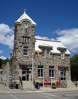
Fergus is located north of Guelph and sits on the Grand River. It is near many natural settings such as the Elora Gorge and Conservation Area, and Belwood Lake. Fergus is a quiet, mostly residential community filled with streets lined with trees, many stone buildings, modern schools, and attractive parklands. It is laid out on a rectangular grid, with the Grand River flowing through the downtown heritage centre, its limestone riverbanks surrounding it.
Climate
Fergus has a humid continental climate (Dfb) under the Köppen climate classification with cold winters and warm summers.
Economy
Fergus and Centre Wellington in general are home to many industries, manufacturers, retailers and trades people. The local economy also benefits greatly from tourism.
Demographics
The 2001 Census was the last Canadian census to record demographic statistics for Fergus as a separate community. The 2006 Census, statistics were published only for Centre Wellington.
For 2001 census:
Education
Fergus and Centre Wellington have two major school boards that operate inside the municipality at a public level. The Wellington Catholic District School Board administers Catholic education in Guelph and Wellington County, operating St. Joseph's Catholic Elementary School (JK-8). The Upper Grand District School Board administers to the area surrounding the upper Grand River operating in Fergus, J. D. Hogarth Public School (K-8), John Black Public School, James McQueen Public School (K-6), Victoria Terrace Public School (K-6).
High Schools
Health Care
Fergus is home to Groves Memorial Community Hospital, a health care centre located on Union Street East in Fergus. Dr. Abraham Groves (1847-1935) was a pioneer of many forms of healthcare in Fergus, and was recognized for his skill and ability as a surgeon. He opened his own hospital, the Royal Alexandria in 1902 and included a nursing school. Before Dr. Groves died in 1935, he gave the hospital to the community. It was then rebuilt as Grove's Memorial Community Hospital.
Attractions
Fergus is best known for the annual Scottish Festival and Highland Games, held in August. The games represent the largest gathering of clans in the world outside Scotland and Cape Breton Island. Competitions are held for music, dancing and 'heavy' events such as the caber toss. A 10 km (6.21 mi) run is also contested.
It also is home to North America's largest truck-show that is held every July, and the Fergus fall fair in September.
Fergus is also home to the Fergus Highland Rugby Football Club. The club plays in the Ontario Rugby Union, and has two Men's teams, two Women's teams and a strong and growing junior program.
St Andrew Street runs parallel to the Grand River on the north side and is the heart of downtown. On the south side of the river is Queen Street where the newly renovated Fergus Market can be found.
The Wellington County Museum and Archives and the Wellington County library are in nearby Aboyne, halfway between Fergus and Elora. The County Museum and Archives are located in a two-storey Italianate-style stone building on a former working farm. The building is the oldest known state-supported poorhouse or almshouse in Canada, and was designated a National Historic Site of Canada in 1995.
A community complex was completed in fall 2006. It includes a 25-metre indoor swimming pool and a second ice rink to complement the previously existing ice facilities.