
State Kingdom of Denmark Region Eysturoy Time zone GMT (UTC+0) Area 286.3 km² Area code 298 | Area rank 2 Calling code 298 Population 10,839 (2011) Island group Faroe Islands | |
 | ||
Gjaargardur guest house gj gv eysturoy faroe islands
Eysturoy (pronounced ['estroi]) (Danish: Østerø) meaning 'East Island' is a region and the second-largest of the Faroe Islands in the North Atlantic, both in size and population.
Contents
- Gjaargardur guest house gj gv eysturoy faroe islands
- Map of Eysturoy Faroe Islands
- Between ei i and gjogv in eysturoy
- DescriptionEdit
- Important Bird AreaEdit
- References
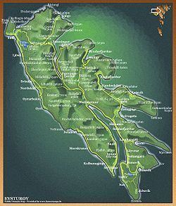
Map of Eysturoy, Faroe Islands
Between ei i and gjogv in eysturoy
DescriptionEdit
Eysturoy is separated by a narrow sound from the main island of Streymoy. Eysturoy is extremely rugged, with some 66 separate mountain peaks, including Slættaratindur, the highest peak in the archipelago. Important settlements on Eysturoy are Fuglafjørður in the north and the densely populated area of the municipalities of Runavík and Nes in the south.
Eysturoy is connected with Streymoy by a road bridge over the sound. The islanders humorously refer to this bridge as the only bridge over the Atlantic. (The natives of the Scottish island of Seil make the same claim, as do the people of Great Bernera in Na h-Eileanan Siar). Leirvík on the east coast of the island is the gateway for transport connections to the north-eastern islands, particularly Klaksvík on the island of Borðoy, which is the Faroes' second-largest town. In 2019, the sub-sea Eysturoy Tunnel is to open a direct link between Runavík, Strendur and Tórshavn, making southern Eysturoy a central place on the Tórshavn-Klaksvík axis.
Sites of interest on Eysturoy include the villages of Eiði and Gjógv, the latter having a small natural port in a rock column; the Blásastova historical museum in the village of Gøta; and the varmakelda (thermal springs) of Fuglafjørður, which indicate the volcanic origin of the archipelago. Off the northern tip of the island are the basalt sea stacks Risin og Kellingin.
Important Bird AreaEdit
The north, north-east, and south-east coasts of the island have been identified as an Important Bird Area by BirdLife International because of their significance as seabird breeding sites, especially for Manx shearwaters (2500 pairs), European storm petrels (500 pairs) and black guillemots (300 pairs).