
State Kingdom of Denmark Area rank 6 Time zone GMT (UTC+0) Area 96 km² Area code 298 | Highest elevation 755 m (2,477 ft) Calling code 298 Population 5,002 (2007) | |
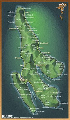 | ||
Borðoy (Danish: Bordø) is an island in the north-east of the Faroe Islands. There are eight settlements: Klaksvík (the second largest town in the Faroes), Norðoyri, Ánir, Árnafjørður, Strond, Norðtoftir, Depil and Norðdepil.
Contents
Map of Bordoy, Faroe Islands
HistoryEdit
There are also three abandoned settlements: Skálatoftir, Múli and Fossá, all in the north. Múli was one of the remotest settlements in the Faroes - there was no road link until 1989, before which goods had to be brought in via helicopter or boat. The last people left in 1994.
A Klaksvík museum bought the Fossá area in 1969 with the plan of turning it into a typical Faroese Medieval village, though the plan never came to fruition.
Important Bird AreaEdit
The northern and south-eastern headlands of the island have been identified as an Important Bird Area by BirdLife International because of their significance as a breeding site for seabirds, especially European storm petrels (250 pairs) and black guillemots (200 pairs).
MountainsEdit
The island has five mountains: Lokki (755 m), Háfjall (647 m), Borðoyarnes (392 m), Depilsknúkur (680 m), Hálgafelli (503 m).