
Country France Time zone CET (UTC+1) Arrondissements 4 Capital Chartres | Department number 28 Area 5,880 km² Population 432,967 (2013) | |
 | ||
Subprefectures ChâteaudunDreuxNogent-le-Rotrou Points of interest Destinations Chartres, Dreux, Châteaudun, Maintenon, Anet | ||
Boom des allergies p nurie d allergologues en eure et loir
Eure-et-Loir ([œ.r‿e.lwaʁ]) is a French department, named after the Eure and Loir rivers.
Contents
- Boom des allergies p nurie d allergologues en eure et loir
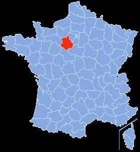
- Map of Eure et Loir France
- france miniature n 81 village de saint symphorien ch teau d esclimont eure et loir
- History
- Geography
- Demographics
- Economy
- Agriculture
- Industries
- Energy
- Politics
- Tourism
- Middle Ages
- Renaissance
- 19th and 20th century
- Media
- References
Map of Eure-et-Loir, France
france miniature n 81 village de saint symphorien ch teau d esclimont eure et loir
History
Eure-et-Loir is one of the original 83 departments created during the French Revolution on March 4, 1790 pursuant to the Act of December 22, 1789. It was created mainly from parts of the former provinces of Orléanais (Beauce) and Maine (Perche), but also parts of Île-de-France (Drouais, Thimerais, Valley of the Avre, Hurepoix).
The current department corresponds to the central part of the land of the Carnutes who had their capital at Autricum (Chartres). The Carnutes are known for their commitment, real or imagined, to the ancient Druidic religion. A holy place in the "Forest of the Carnutes" used to host the annual Druidic assembly. In the north of the department another pre-Roman people, the little-known Durocasses, had their capital at Dreux.
Geography
Eure-et-Loir comprises the main part of the region of Beauce, politically it belongs to the current region of Centre-Val de Loire and is surrounded by the departments of Loir-et-Cher, Loiret, Essonne, Yvelines, Eure, Orne, and Sarthe.
Demographics
The inhabitants of the department are called Euréliens.
Economy
The Eure-et-Loir is a department of agricultural tradition (Beauce), but also at the forefront in three economic sectors :
Agriculture
The department is a major economic player in the production of grain and oilseed in France. Its agricultural economy is still heavily dependent on economic and regulatory environment of the markets for crops. The Eure-et-Loir region is the first grain producer of France. It is also the national leader in the production of rapeseed and peas. Wheat production is by far the most dominant in the area. Nearly 40% of all farmland is devoted to the cultivation of wheat, which has generated an average of 29% of the commercial agricultural production of the department over the last 5 years.
Agriculture in the department is also promoted by the "Pôle AgroDynamic", a groupment of subsidiaries providing added values in different sectors: agro-energy, agribusiness, agricultural materials, Agrohealth.
Industries
Energy
The department also has the lead in renewable energy. Already ranked second nationally in terms of power generation through its wind farms located in particular in the Beauce region of Eure-et-Loir in 2012 will be the largest producer of electricity with photovoltaic French original creation on the airbase NATO disused Crucey-Villages near Brezolles in the region's natural Thymerais, the largest photovoltaic park in France. Given in February 2011 by the General Council to the operator, EDF Energies Nouvelles, the park will cover 245 ha of the military base and produce the equivalent output of 160 wind turbines.
Politics
The President of the General Council is Albéric de Montgolfier of the Union for a Popular Movement.
Tourism
Middle Ages
Renaissance
19th and 20th century
Media
The media in Eure-et-Loir include the following: