
- elevation 300 m (984 ft) - average 0.5 m/s (18 cu ft/s) | - elevation 74 m (243 ft) Length 61 km Country Canada | |
 | ||
Similar Mimico Creek, Lake Ontario, Humber River, Marie Curtis Park, Don River | ||
Etobicoke creek trout
Etobicoke Creek /ɛˈtoʊbᵻkoʊ/ is a river in the Greater Toronto Area of Ontario, Canada. It is a tributary of Lake Ontario and runs from Caledon to southern Etobicoke, part of the City of Toronto. The creek is within the jurisdiction of the Toronto and Region Conservation Authority.
Contents
- Etobicoke creek trout
- Map of Etobicoke Creek Ontario Canada
- Tltv ep 57 etobicoke creek trail part 1
- EtymologyEdit
- CourseEdit
- WatershedEdit
- GeologyEdit
- Aircraft accidentsEdit
- NeighbourhoodsEdit
- TributariesEdit
- References
Map of Etobicoke Creek, Ontario, Canada
Tltv ep 57 etobicoke creek trail part 1
EtymologyEdit
The name "Etobicoke" was derived from the Mississauga word wah-do-be-kang (wadoopikaang), meaning "place where the alders grow", which was used to describe the area between Etobicoke Creek and the Humber River. The first provincial land surveyor, Augustus Jones, also spelled it as "ato-be-coake". Etobicoke was adopted as the official name of the township (later city, now part of the city of Toronto) in 1795 on the direction of Lieutenant Governor John Graves Simcoe. The name for the creek officially was adopted by the Geographical Names Board of Canada on November 18, 1962, though it existed far earlier.
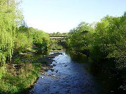
CourseEdit
Etobicoke Creek begins south of the Oak Ridges Moraine and flows through Caledon, Brampton, and Mississauga — west of the Toronto Pearson International Airport and the surrounding industrial area — to its mouth at Lake Ontario in the Etobicoke portion of the city of Toronto. The length of the creek is 61 kilometres (38 mi).
WatershedEdit
The creek's southern section forms a city and county-level boundary, separating Toronto on the east from Mississauga, part of the Regional Municipality of Peel, on the west. Previously the eastern side was part of Etobicoke, which was part of Metropolitan Toronto. The watershed encompasses 211 square kilometres (81 sq mi). Mean summer waterflow has increased over the period 1967 to 2006 from 3.5 m3/s to 5.0 m3/s as recorded at a measuring station near the river mouth at the Queen Elizabeth Way.
The creek ends in a large recreational area, Marie Curtis Park. It is surrounded by big cliffs and the bottom is solid stone, often covered with smaller rocks. It is full of little fish and crayfish, a sign of purity of water.
GeologyEdit
The creek is characterized by winding paths ravines and shale banks.
Aircraft accidentsEdit
A section of Etobicoke Creek runs close to Toronto's Pearson International Airport, leaving a ravine very close to the west ends of runways 24L and 24R or the beginnings of Runways 6R & 6L. There have been two major aircraft incidents which have resulted in aircraft in the ravine.
The position of the ravine so close to the airport's overrun area has raised some concerns among the general public, despite Toronto Pearson's compliance with all safety regulations. Work to fill the ravine or divert the creek would probably be very expensive and might face opposition from environmentalists. There are no known plans to make any landscaping changes.