
Population 12,347 (2011 census) Local time Tuesday 4:25 AM | Postcode(s) 2122 Postal code 2122 | |
 | ||
Weather 21°C, Wind E at 14 km/h, 89% Humidity Points of interest Terrys Creek, ELS Hall Park, Pioneer Park | ||
Marsfield is a suburb that is part of the Northern Suburbs of Sydney, Australia. The green residential suburb is noted for its proximity to a number of leading scientific and tertiary educational institutions. Marsfield is located 16 kilometres north-west of the Sydney central business district in the local government area of the City of Ryde. Due to its close proximity to Macquarie University, the Macquarie Park Business Park, Macquarie University Hospital, Macquarie University railway station and Macquarie Shopping Centre, it is a growing suburb.
Contents
- Map of Marsfield NSW 2122 Australia
- History
- Aboriginal culture
- European settlement
- Boundaries
- Landmarks and institutions
- Housing
- Public Transport
- Demographics
- References
Map of Marsfield NSW 2122, Australia
History
The suburb's name is derived from Field of Mars, the original name in the early days of British colonisation of Australia, given to the area by Governor Phillip in 1792 .
Aboriginal culture
The whole area between the Parramatta and Lane Cove Rivers was originally known by its Aboriginal name Wallumatta. The aboriginal name survives in a local park, the Wallumatta Nature Reserve, located at the corner of Twin and Cressy Roads, North Ryde.
European settlement
In 1792 Governor Phillip began the granting of parcels of lands to Royal Marines, and the area was referred to on Phillip's maps as the Field of Mars, named after the Roman Field of Mars probably because of the military link. The area was later part of the suburb of North Ryde, and many consider that Marsfield is still a part of the greater North Ryde area. Field of Mars was also the name for the parish proclaimed in 1835.
In 1874, following extensive debate including a Parliamentary Select Committee, the government resumed the Common for sale and settlement by small farmers, using the money to fund bridges across the Parramatta River at Gladesville and Iron Cove. The land was subdivided into small farms of between 0.4 and 1.6 ha (1–4 acres), and released for sale in stages, starting in 1885.
Many of the streets in Marsfield and bordering suburbs, mainly Eastwood and Macquarie Park, are named after famous historical conflicts or battles, such as Abuklea Road, Agincourt Road, Alma Road, Balaclava Road, Buffalo Road (Gladesville), Busaco Road, Corunna Road, Cressy Road (East Ryde), Crimea Road, Culloden Road, Fontenoy Road, Khartoum Road, Plassey Road, Talavera Road, Taranto Road, Torrington Road, Trafalgar Place, Vimiera Road, Waterloo Road.
In 1894, the "Municipality of Marsfield" formed its own local government, splitting from Ryde Municipality.
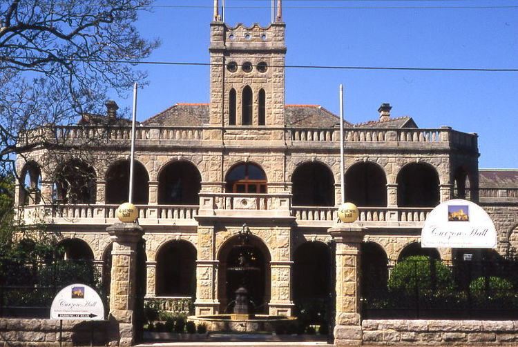
Stately, historical Curzon Hall was built in the 1890s by Harry Smith and named after his wife Isabella Curzon-Smith. The house was bought in 1921 by the Society of Saint Vincent de Paul which established St Joseph's Seminary on the premises. It now serves as a function centre.
Until the 1950s, substantial parts of the North Ryde/Marsfield area were part of the "Green Belt" which prevented building houses on lots of less than 2 ha (5 acres). The Marsfield-North Ryde Green Belt boundaries were revised and in December 1959, 688 ha (1,700 acres) of land was rezoned. The last Green Belt land was released in September 1969 to build Macquarie Shopping Centre and Macquarie University.
Boundaries
Marsfield is bounded by the Lane Cove River, Macquarie University Sports Fields, Talavera Road, Culloden Road, Waterloo Road, Vimiera Road, Marsfield Park and Culloden Road in the north, Epping Road, Shrimptons Creek, Kent Road, Ruse Street and Shrimptons Creek in the east, Bridge Road and Abuklea Road in the south and Terrys Creek in the west.
Landmarks and institutions
Marsfield is home to:
Housing
This green suburb features large, modern homes on the higher parts with views, and townhouses/units in the parts of the suburb that border South Turramurra and Epping. A large number of the residents are students of Macquarie University.
The structures of these homes are well distributed: at the 2011 census, about one-third (33.4%) of private dwellings were separate houses, somewhat more (38.6%) were semi-detached (townhouses etc.), and 27.9% were flats, units or apartments. Nearly two-thirds (62.7%) were family households, 27.0% were single person households and 10.4% were group households. The average household size was 2.5 people. The tenure was split almost evenly between 34.9% of properties that were rented, 30.8% owned outright, and 29.0% owned with a mortgage.
Public Transport
A number of bus routes service Marsfield. The 292/293 routes run from the city through Lane Cove and terminate in Busaco Road while other many routes e.g. 288/290 travel along Epping Road to Epping station. Macquarie University railway station is located on Herring Road between the university and Macquarie shopping centre.
Demographics
At the 2011 census, Marsfield recorded a population of 12,347. Of these: