
Country Canada Rural municipality Emerson – Franklin Amalgamated January 1, 2015 Area 22.28 km² Population 689 (2006) | Region Pembina Valley Incorporated November 3, 1879 Time zone CST (UTC-6) Elevation 242 m Local time Thursday 5:53 PM | |
 | ||
Weather -18°C, Wind NW at 35 km/h, 62% Humidity | ||
Emerson is an unincorporated community recognized as a local urban district in south central Manitoba, Canada, located within the Municipality of Emerson – Franklin. It has a population of 655.
Contents
- Map of Emerson MB Canada
- Location and transportation
- Emerson port of entry
- History
- West Lynne
- Fort Dufferin
- Government
- Community services
- Climate
- Television
- References
Map of Emerson, MB, Canada
Location and transportation
Emerson, named after writer Ralph Waldo Emerson, is located 96 kilometers south of Winnipeg along the Red River, just north of the United States border at the point where the province of Manitoba and states of Minnesota and North Dakota meet. The community is bordered by the Rural Municipality of Montcalm in Manitoba, Pembina County in North Dakota, and Kittson County in Minnesota. The towns of St. Vincent, Minnesota and Pembina, North Dakota are located just a few kilometers south of the border in the United States. The unincorporated community of Noyes, Minnesota lies immediately across the border from Emerson, however the border crossing between the two is now closed.
The principal roads serving Emerson are Highway 75, which runs from the border north to Winnipeg, and Provincial Road 200, which begins at Highway 75, which runs through the community and north to Winnipeg along the east side of the Red River.
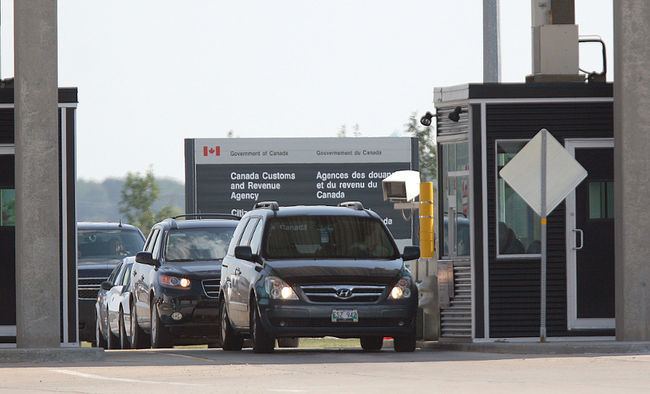
Emerson port of entry
The border crossing at Emerson, Manitoba and Pembina, North Dakota is the fifth busiest along the Canada–United States border, and the second busiest west of the Great Lakes. It is part of a large trade corridor that links the Canadian prairies with the United States and Mexico. Annual cross-border trade is valued at approximately $14 billion CAD. The ports of entry on both sides are open 24 hours and offer full border services. An estimated one million people pass through the border crossing each year.
For many years, Emerson was among very few communities in Canada to have multiple border crossings, as it was serviced by both the current port of entry (originally designated as West Lynne) and the now-closed Emerson East port of entry opposite Noyes, Minnesota. In its original configuration, Highway 75 came from the north, crossed the river at Emerson and ended at the Emerson East crossing, then the more commonly used border crossing, where it continued south as U.S. Route 75. Travelers wishing to enter North Dakota would have to turn south at an intersection about 0.5 kilometers north of the border onto a short road (later designated as Highway 29) leading to the Manitoba-North Dakota border and then continue south on U.S. Route 81.
The importance of Emerson East crossing began to decline after Interstate 29 superseded U.S. 81 in 1957. The Highway 75/29 junction was rebuilt in the 1980s to direct through traffic to the West Lynne-Pembina crossing, making it the new primary border crossing. Travelers wanting to continue on Highway 75 were afterwards required to turn east at the junction. Use of the Emerson East port of entry dwindled, which prompted the Canadian government to close it in 2003, leaving that crossing open to U.S. bound traffic only. The crossing was completely barricaded when the American government closed the Noyes port of entry three years later. The Manitoba government formally re-routed Highway 75 and Provincial Road 200 to its current configuration in 2012.
In order to accommodate future expansion, planning is currently underway to redesign the Highway 75 approach to the Emerson port of entry.
South of Emerson, two major U.S. rail lines, the BNSF Railway (Formerly the Great Northern Railway) and the Soo Line Railroad cross the border and are met, respectively, by the Canadian National and Canadian Pacific Railways. There are customs inspection facilities for both lines on both sides of the border.
History
In 1873, American businessmen Thomas Carney and William Fairbanks, following advice from railroad entrepreneur James J. Hill, received a grant from the Province of Manitoba for 640 acres along the east side of the Red River near the Canada–United States border. Hill had advised Carney and Fairbanks that the area had significant potential to become a railway hub for the region. The existing settlement of West Lynne on the west side of the river had already established itself as a key point along the trading routes between Winnipeg and St. Paul, Minnesota. With the emergence of railroads during this time, the addition of their own railway would bring great economic prosperity.
In 1874, the two men led a group of 100 who formed the new settlement of Emerson, which was named after writer and poet Ralph Waldo Emerson. With the promise that Emerson could be the new "gateway to the west", the settlement grew quickly and, by 1876, a church and a school were built.
Manitoba's first railway, the Emerson Line, which ran along the east side of the Red River from St. Boniface to Emerson was completed in 1878. Soon after, the railway from St. Paul to St. Vincent, Minnesota was completed and the two lines were connected. The arrival of the railway to Emerson brought prosperity, and instantly elevated Emerson's status as one of Manitoba's most important settlements.
Emerson was originally incorporated as a town in 1879. Over the next four years, the community experienced a boom. Its population swelled to over 10,000 and in 1883, the community absorbed the neighbouring community of West Lynne. A court house, town hall, and other large, elaborate structures were erected as businesses thrived, thanks to immigrants and travelers from the east stopping in Emerson before embarking west. To help cement its status as "gateway to the west", the town negotiated with Canadian Pacific Railway to build a new railway west from Emerson. However, shortly after work on the line began, CPR reconsidered and the railway was never built.
Coupled with the completion of CPR's transcontinental railroad through Winnipeg, the loss of the western railway ended the prospects of Emerson being the "gateway to the west", a title that would be bestowed upon Winnipeg. Businesses relocated to Winnipeg and travelers who would previously would have come to Manitoba through Emerson were now taking the new all-Canadian CPR route to Winnipeg and then west. By 1884, only ten years after the settlement was founded, the community was bankrupt. It would take the community years to recover.
A fire destroyed the original town hall in 1917. A new town hall was built to replace it, with help from the Manitoba government. Many of the abandoned buildings were eventually destroyed by Red River floods, while others were removed to make way for the dike that was constructed around the community.
From around 1936 to 1956, Emerson obtained its power across the border from a long 2400-volt distribution circuit originating from Pembina. This line was initially operated by the Interstate Power Company and was sold to the Otter Tail Power Company in 1944. In 1956, the town made arrangements to obtain its electrical needs from Manitoba Hydro and the cross-border distribution line was removed.
Today, Emerson has a population just under 700 and prides itself on being a "charming, friendly town". The community still attracts many visitors each year who pass through the Port of Entry at Emerson. There are still some landmarks remaining from Emersons golden age, such as the court house, jail, and home of William Fairbanks, as well as the West Lynne post office and original customs house. The Court House, which is designated as a historical landmark, is still in use today.
West Lynne
West Lynne was established in the early 1870s by the Hudson's Bay Company, next to their North Pembina post. Prior to this, Hudson's Bay Company had been operating a post at Fort Pembina, which was two miles further south in American territory, but after losing the fort in a Fenian raid in 1871, they withdrew and established the post inside Canadian territory.
A post office, telegraph station, and customs house were soon constructed at West Lynne, making it a key point along the Red River trade routes for both river and land traffic.
After the railway to Emerson was completed in 1878, the importance of West Lynne diminished. In 1883, West Lynne and Emerson were amalgamated into one municipality, retaining the name Emerson. The Canadian port of entry on the west side of the river was officially known as West Lynne to distinguish it from the Emerson East port on east side until the Canadian government closed Emerson East in 2003 to consolidate operations.
The original customs house and post office at West Lynne still stand about 200 meters from the modern facility used by the Canada Border Services Agency.
Fort Dufferin
The fort was located on the west side of the Red River, approximately two kilometers north of West Lynne. It was established by the Government of Canada in 1872 as a base for their contingent of the North American Boundary Commission. The commission was tasked with defining and marking the Canada-U.S. border. It later served an immigration station and police post. By 1879, the Canadian government no longer had use for the fort and sold the property.
Fort Dufferin is best known as the starting point for the North-West Mounted Police's infamous March West in 1874. This marked the only time the entire force was ever assembled at one place.
Today, the Fort Dufferin site is owned by the Province of Manitoba. A cairn and plaque mark the historic site, which is open to the public during the summer.
Government
Emerson is located at the far southwest corner of the federal riding of Provencher, which is represented by Ted Falk. At the provincial level, the community is represented by Cliff Graydon, MLA for the Emerson riding.
On January 1, 2015, the former Town of Emerson amalgamated with the neighbouring Rural Municipality of Franklin to form the Municipality of Emerson – Franklin. This move was necessary in order to satisfy an ultimatum from the Manitoba government, as part of a plan to amalgamate smaller municipalities in the province. Emerson now operates as a local urban district within the new municipality and has two seats on the municipal council.
Community services
The community's education needs are served by Emerson Elementary School (Kindergarten to Grade 8) and Roseau Valley School (Grades 9-12) in nearby Dominion City. Recreational facilities include an indoor skating rink, curling rink, public golf course, swimming pool, and park. Emerson is also served by a local RCMP detachment and volunteer fire department.
Climate
Emerson experiences a humid continental climate (Dfb), and a Plant Hardiness of zone 3b. Along with St. Albans, Emerson holds the record for Manitoba's highest temperature of 44.4 °C (112 °F) on 12 July 1936. The coldest temperature ever recorded was −46.7 °C (−52 °F) on 9 February 1899.