
Country Chile Elevation 8 m (26 ft) Area code(s) 56 + 35 Area 98.8 km² | Time zone CLT (UTC-4) Website www.eltabo.cl | |
 | ||
Dia y noche su propia guerra part 1
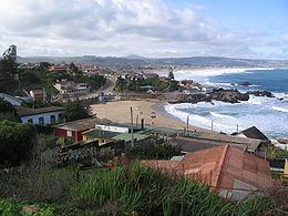
El Tabo is a Chilean commune located in the San Antonio Province, Valparaíso Region. The commune spans an area of 98.8 km2 (38 sq mi).
Contents
- Dia y noche su propia guerra part 1
- Map of El Tabo ValparaC3ADso Chile
- Demographics
- Notable residents
- Administration
- References
Map of El Tabo, Valpara%C3%ADso, Chile
Demographics
According to the 2002 census of the National Statistics Institute, El Tabo has 7,028 inhabitants (3,537 men and 3,491 women). Of these, 6,604 (94%) lived in urban areas and 424 (6%) in rural areas. The population grew by 55.7% (2,515 persons) between the 1992 and 2002 censuses.
Notable residents
Administration
As a commune, El Tabo is a third-level administrative division of Chile administered by a municipal council, headed by an alcalde who is directly elected every four years. The 2008-2012 alcalde is Emilio Jorquera Romero (PPD). The council has the following members:
Within the electoral divisions of Chile, El Tabo is represented in the Chamber of Deputies by Mrs. María José Hoffmann (UDI) and Mr. Víctor Torres (PDC) as part of the 15th electoral district, (together with San Antonio, Santo Domingo, Cartagena, El Quisco, Algarrobo and Casablanca). The commune is represented in the Senate by Francisco Chahuán Chahuán (RN) and Ricardo Lagos Weber (PPD) as part of the 6th senatorial constituency (Valparaíso-Coast).