
Area rank 214 in Norway Area 469.2 km² Local time Wednesday 12:46 AM | Demonym(s) EidarEider Population 5,920 (2013) | |
 | ||
Weather -6°C, Wind E at 10 km/h, 57% Humidity Points of interest Harpefossen, Løkjastranda, Rødstranda | ||
Eid is a municipality in the county of Sogn og Fjordane, Norway. It is located in the traditional district of Nordfjord. The village of Nordfjordeid is the administrative center of the municipality. Other larger villages in Eid include Mogrenda, Stårheim, Haugen, Kjølsdalen, Heggjabygda, and Lote
Contents
- Map of Eid Norway
- General information
- Name
- Coat of arms
- Churches
- Government
- Municipal council
- Mayor
- Geography
- Famous people
- References
Map of Eid, Norway
Eid is known for its opera, fjord horses, shopping, and hiking opportunities. As in the rest of the region, agriculture is very important here, but trade and industry are also important. Frislid Konfeksjon (textiles) and the Hellesøy Nordfjord shipyard among others are located in Eid.
Nordfjordeid has much to offer in the way of education. Its schools include the folk high school, which offers courses linked to Fjord horses and provides the only circus education in Norway. There is also the Norwegian Fjord Horse Centre (Norsk Fjordhestsenter) in Eid. Its focus is in boosting the breed's standing in Norway and elsewhere.
General information
Eid was established as a municipality on 1 January 1838 (see formannskapsdistrikt). The original municipality was identical to the Eid parish (prestegjeld) with the sub-parishes (sokn) of Hornindal, Eid, and Stårheim. On 1 January 1867, the eastern district of Hornindal was separated from Eid to form its own municipality. This split left the two remaining sub-parishes of the municipality of Eid with a population of 2,918.
On 1 January 1965, the neighboring municipalities of Davik and Hornindal were dissolved and split up among their neighbors. Eid municipality gained all of Davik that was north of the Nordfjorden and east of and including the village of Lefdal. (Population in that area was 654.) All of Hornindal municipality west of and including the villages of Navelsaker and Holmøyvik (population: 310) was also merged into Eid. After this merger, Eid's total population was 4,532. At this point, Eid gained a third sub-parish from the former municipality of Davik: Kjølsdalen. Then on 1 January 1992, the village of Lote and its surrounding area (population: 152) was transferred from Gloppen Municipality to Eid.
Name
The Old Norse form of the name was Øygir; this was originally the name of a fjord (now called the Eidsfjord). The name of the fjord is probably derived from a river name Aug, and this again is derived from the word öfugr which means "backwards". The actual river (now called Eidselva) meanders back and forth and from certain points it can seem to run backwards.
Coat of arms
The coat of arms were granted on 26 April 1986. The arms show the golden head of a fjord horse on a red background. The region is well known for its own race of horses, called the Fjording, that are very common and popular in the area. The Fjording is characterised by its white and black mane.
See also: Coat of arms for Gloppen, Levanger, Lyngen, Nord-Fron, Skedsmo and SkiChurches
The Church of Norway has three parishes (sokn) within the municipality of Eid. It is part of the Nordfjord deanery in the Diocese of Bjørgvin.
Government
All municipalities in Norway, including Eid, are responsible for primary education (through 10th grade), outpatient health services, senior citizen services, unemployment and other social services, zoning, economic development, and municipal roads. The municipality is governed by a municipal council of elected representatives, which in turn elect a mayor.
Municipal council
The municipal council (Kommunestyre) of Eid is made up of 29 representatives that are elected to every four years. For 2007-2011, the party breakdown is as follows:
Mayor
The mayor (ordførar) of a municipality in Norway is a representative of the majority party of the municipal council who is elected to lead the council. Alfred Bjørlo of the Liberal Party was elected mayor for the 2011-2015 term.
Geography
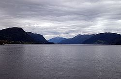
The municipality of Eid is located in the northernmost part of Sogn og Fjordane county. It is located along the northern shores of the Nordfjorden and it surrounds the Eidsfjorden branch off of the main Nordfjorden. Eid is bordered to the west by the municipality of Vågsøy, to the south by the municipalities of Bremanger and Gloppen, to the east by the municipalities of Stryn and Hornindal, and to the north by the municipalities of Volda and Vanylven in Møre og Romsdal county. Hornindalsvatnet, the deepest lake in Europe, is partially located in Eid municipalithy.