
Country United States County Carroll Time zone Eastern (UTC-5) Elevation 182 m Zip code 03882 | Incorporated 1778 Area code(s) 603 Area 102.6 km² Population 1,465 (2010) | |
 | ||
Weather 1°C, Wind SE at 5 km/h, 82% Humidity | ||
How to say or pronounce usa cities effingham new hampshire
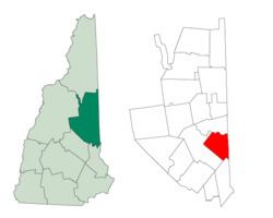
Effingham is a town in Carroll County, New Hampshire, United States. At the 2010 census, the town population was 1,465. Effingham includes the villages of Effingham Falls, Effingham (Lord's Hill), Center Effingham (Drake's Corner), and South Effingham. Pine River State Forest is in the south.
Contents
- How to say or pronounce usa cities effingham new hampshire
- Map of Effingham NH 03882 USA
- History
- Geography
- Demographics
- References
Map of Effingham, NH 03882, USA
History
The town was settled by members of the Leavitt family of Hampton, led by Captain John Leavitt, a soldier whose father, Moses, was a prosperous Hampton tavern keeper. From them the settlement first took the name Leavitt's Town. In 1749, the land was granted by Governor Benning Wentworth, and he renamed it Effingham for the Howard family, who were Earls of Effingham and who were related to the Wentworths by marriage. The town was incorporated in 1778. North Effingham would be set off in 1831 and incorporated as Freedom. By 1859, when the population was 1,252, Effingham Falls had developed into a small mill town, with a woolen factory, five sawmills, three gristmills, and a carriage factory.
Effingham was home to the first normal school in New Hampshire, established in 1830 on the second floor of the Effingham Union Academy Building, erected in 1819. James W. Bradbury, later a Maine senator, took charge of the school only on condition that it should be for the "instruction and training of teachers." The idea was his own and, at that time, entirely novel.
Geography
According to the United States Census Bureau, the town has a total area of 39.6 square miles (103 km2), of which 38.4 square miles (99 km2) is land and 1.2 square miles (3.1 km2) is water, comprising 2.98% of the town. Green Mountain, elevation 1,884 feet (574 m) above sea level, is the highest point in town. Effingham is drained by the Ossipee River and the Ossipee's tributaries, the Pine and South rivers. Province Lake lies partially within the town's borders to the south, and small portions of Ossipee Lake (Broad Bay and Berry Bay) are contained to the north. The community is bounded on the east by the Maine state line, and on the north by the Ossipee River. Effingham lies fully within the Saco River watershed. Effingham lies partially in the Ossipee River watershed, home to the largest stratified-drift aquifer east of the Mississippi River. Much of Effingham's land serves as aquifer recharge areas.
The town is served by state routes 25 and 153.
Demographics
As of the census of 2000, there were 1,273 people, 490 households, and 336 families residing in the town. The population density was 33.0 people per square mile (12.7/km²). There were 791 housing units at an average density of 20.5 per square mile (7.9/km²). The racial makeup of the town was 98.35% White, 0.39% African American, 0.31% Native American, 0.24% Asian, 0.08% from other races, and 0.63% from two or more races. Hispanic or Latino of any race were 0.39% of the population.
There were 490 households out of which 29.0% had children under the age of 18 living with them, 53.5% were married couples living together, 10.6% had a female householder with no husband present, and 31.4% were non-families. 23.3% of all households were made up of individuals and 7.6% had someone living alone who was 65 years of age or older. The average household size was 2.43 and the average family size was 2.88.
In the town, the population was spread out with 26.0% under the age of 18, 6.6% from 18 to 24, 29.2% from 25 to 44, 25.6% from 45 to 64, and 12.6% who were 65 years of age or older. The median age was 38 years. For every 100 females there were 106.7 males. For every 100 females age 18 and over, there were 106.1 males.
The median income for a household in the town was $36,000, and the median income for a family was $38,000. Males had a median income of $29,650 versus $22,188 for females. The per capita income for the town was $17,089. About 8.1% of families and 15.3% of the population were below the poverty line, including 13.4% of those under age 18 and 6.3% of those age 65 or over.