
Other name(s) Econ River Basin area 700.7 km² | Etymology "Rivers of mounds" Length 88 km Source elevation 20 m | |
 | ||
Main source Lake Conlinnorth of Holopaw92 feet (28 m) River mouth St. Johns Rivernear Puzzle Lake3 feet (0.91 m) Progression Ecolockhatchee - Saint Johns River - Atlantic Ocean | ||
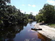
Econlockhatchee river in oviedo florida
The Econlockhatchee River (Econ River for short) is an 87.7-kilometer-long (54.5 mi) north-flowing blackwater tributary of the St. Johns River, the longest river in the U.S. state of Florida. The Econ River flows through Osceola, Orange, and Seminole counties in Central Florida, just east of the Orlando Metropolitan Area (east of State Road 417). Its name means "River of mounds", and it is a designated Outstanding Florida Waters.
Contents
- Econlockhatchee river in oviedo florida
- Map of Econlockhatchee River Florida USA
- Econlockhatchee River SwampEdit
- References
Map of Econlockhatchee River, Florida, USA
The river flows north from its source, Lake Conlin, through the Econlockhatchee River Swamp (see below) south of State Road 528. Near the City of Oviedo, the tributary Little Econlockhatchee River joins, and the river turns east as it flows through the Little Big Econ State Forest. The Econlockhatchee joins the St. Johns River near Puzzle Lake. The river's floodplain is forested for its entire length.
Econlockhatchee River SwampEdit
The upper course of the river is called the Econlockhatchee River Swamp. Located southeast of Orlando, the swamp is 21 kilometres (13 mi) long, from Lake Conlin to State Road 528. South of State Road 532, the swamp is known as Cat Island Swamp, named after an island near County Road 500A. The river is at its widest (1.6 km) here, bordered by Lake Preston to the west. Seven miles downstream, the river's elevation is 19 metres (62 ft). The Disston Canal joins Lake Mary Jane and Lake Hart to the swamp. Turkey Creek Bay is an arm of the swamp, through which the tributary Turkey Creek flows. North of Wewahootee Road, the Econlockhatchee River leaves the swamp and remains a free-flowing river for the rest of its journey to the St. Johns River.