
Airport type Public Code BIH Phone +1 760-872-2971 | Elevation AMSL 4,124 ft / 1,257 m Elevation 1,257 m | |
 | ||
Owner City of Los AngelesDepartment of Public Works Location Inyo County, east of Bishop Address 703 Airport Rd, Bishop, CA 93514, USA Similar Tri County Fairgroun, Eastern Sierra Transit A, Inyo County Animal S, Brown's Town Campgro, US Forest Services Supervisor | ||
Eastern Sierra Regional Airport (IATA: BIH, ICAO: KBIH, FAA LID: BIH) is two miles east of Bishop, in Inyo County, California. It is owned by the City of Los Angeles, Department of Public Works and operated by Inyo County.
Contents
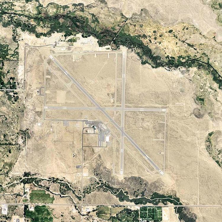
Facilities
The airport covers 830 acres (340 ha) at an elevation of 4,124 ft (1,257 m). It has three asphalt runways: 7/25 is 5,566 by 100 ft (1,697 by 30 m); 12/30 is 7,498 by 100 ft (2,285 by 30 m); 16/34 is 5,600 by 100 ft (1,707 by 30 m). It has two helipads: H1 is 40 by 40 ft (12 by 12 m) and H2 is 100 by 100 ft (30 by 30 m).
In the year ending October 23, 2006 the airport had 26,000 aircraft operations, average 71 per day: 88% general aviation and 12% military. 64 aircraft were then based at the airport: 81% single-engine, 13% multi-engine, 2% jet and 5% glider.
Historical military use
The airfield opened in April 1940 on 897.22 acres (363.09 ha) subleased from Inyo County. During World War II it was known as Bishop Army Airfield and was a sub-base to Muroc Army Airfield in 1942 and 1943 for Fourth Air Force. The site was used for aircraft flight and ordnance delivery training. In 1943 it was reassigned to Tonopah Army Airfield, Nevada. Aircraft maintenance was also done, and ordnance storage.
After the end of World War II, Bishop AAF was turned over to Air Technical Service Command as a storage airfield. On 2 May 1949, Army cancelled its initial lease of 897.22 acres (363.09 ha) with Inyo County for Bishop Airport under the War Assets Administration's Peacetime Reduction Mission, and the base was declared excess to requirements and returned to civil control.
The U.S. Air Force subleased runway use rights and a heliport area of 4.76 acres (1.93 ha) known as the Bishop Test Site from Inyo County from 15 November 1965 to 19 June 1971 and from 25 November 1980 to 30 September 1985. The Air Force used the heliport area and runway for performance testing of helicopters and other aircraft. The U.S. DoD facilities included runway expansion, fuel facilities, utilities, buildings, aircraft maintenance, hospital and barracks.
Today, the airport is owned by the City of Los Angeles, California and is leased to Inyo County.
Historical airline service
Trans Sierra Airlines, a commuter air carrier, was serving the airport in 1971 with two daily flights to Los Angeles (LAX) and two daily flights to San Jose (SJC) operated with Cessna 402 twin prop aircraft. Trans Sierra then changed its name to Sierra Pacific Airlines which during the mid 1970s was operating direct service to Burbank (BUR) in the Los Angeles area and also to Las Vegas (LAS) via an intermediate stop at the nearby Mammoth Yosemite Airport as well as nonstop service to Fresno (FAT) with Handley Page Jetstream commuter propjets. In 1980 and 1981, Air Sierra was operating nonstop flights to Fresno with Piper Navajo twin prop aircraft. Also in 1981, Wings West Airlines was operating direct flights to Santa Monica (SMO) and Sacramento (SMF) via an intermediate stop at Mammoth Lakes Yosemite Airport as well as nonstop service to Oakland (OAK) with Cessna 402 twin prop aircraft. In 1983, Mojave Airlines was operating flights to Los Angeles (LAX), San Diego (SAN), Ontario (ONT), Inyokern (IYK) and Fox Field (WJF) in Lancaster with Beechcraft C99 commuter turboprops. By 1988, Alpha Air was providing commuter airline service with Beechcraft 1900C propjets direct to Los Angeles (LAX) and Oakland (OAK) as well as nonstop service to San Jose (SJC).
The airport currently does not have scheduled passenger flights although airline service is available from the Mammoth Yosemite Airport (MMH).