
Country Area 48,718.10 km2 | Language spoken Capital Population 5.344 million (2012) | |
 | ||
Colleges and Universities University of Nusa Cendana, Artha Wacana Christian University Destinations | ||
Governor Benny Alexander Litelnoni | ||
Map of East Nusa Tenggara
East Nusa Tenggara (Indonesian: Nusa Tenggara Timur – NTT) is the southernmost province of Indonesia. It is located in the eastern part of the Lesser Sunda Islands and includes West Timor. It has a total area of 48,718.1 km2, and the population at the 2010 Census was 4,683,827; the latest official estimate in January 2014 was 5,070,746. The provincial capital is Kupang on West Timor.
Contents
- Map of East Nusa Tenggara
- Nusa tenggara timur festival nasional musik tradisi anakanak 2014 by mam eo
- Indonesia trip bajawa flores east nusa tenggara indonesia mopon en
- History
- Geography
- Administrative divisions
- Provincial Government
- Demographics
- Religion
- Economy
- Agriculture
- Natural resources
- Growth and development
- Tourism
- Well known figures
- References
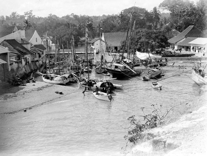
The province consists of more than 500 islands, the three largest being Flores, Sumba, and the western half of Timor (West Timor). The eastern part of Timor is the independent country of East Timor.
East Nusa Tenggara is the only province in Indonesia where Roman Catholicism is the predominant religion. Nusa Tenggara Timur, in Indonesian, means "eastern southeastern islands"; compare to Nusa Tenggara Barat, which means "western southeastern islands" where Lombok and Sumbawa are located.
Nusa tenggara timur festival nasional musik tradisi anakanak 2014 by mam eo
Indonesia trip bajawa flores east nusa tenggara indonesia mopon en
History
After the declaration of Indonesian independence in 1945, the eastern part of Indonesia declared the State of East Indonesia. The state was further included in the United States of Indonesia as part of the agreement with the Dutch contained in the transfer its sovereignty to Indonesia in 1949.
In 1950, United States of Indonesia dissolved itself into a unitary state and began to divide its component area into provinces. In 1958, by Indonesian law (Undang-Undang) No. 64/1958, three provinces were established in the Lesser Sunda Islands, namely Bali, West Nusa Tenggara and East Nusa Tenggara. The area of East Nusa Tenggara province included the western part of Timor island, Flores, Sumba and other several small islands in the region. The province was sub-divided into twelve regencies and the City of Kupang, which had regency-level status.
Following the fall of the Suharto regime in 1998 and the passage of a new regional autonomy law, there was a dramatic proliferation (known as pemekaran) of regional governments across Indonesia (at both provincial and regency level). Several new regencies were created in East Nusa Tenggara by the division of existing regencies:
Therefore, as of early 2013, there were twenty-one regencies plus the one autonomous city (Kupang) in the province.
Geography
Located in the east of Lesser Sunda Islands, East Nusa Tenggara faces the Indian Ocean in the south and Flores Sea in the north. The province is bordered by other provinces, West Nusa Tenggara in the west. In the east, the province is bordered by East Timor and southern part of Maluku.
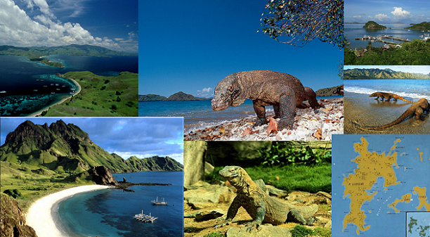
The province consists of about 566 islands, the largest and most dominant are Flores, Sumba, and the western part of Timor. The other is smaller islands include Adonara, Alor, Komodo, Lembata (formerly called Lomblen), Menipo, Raijua, Rincah, Rote Island (the southernmost island in Indonesia), Savu, Semau, and Solor. The highest point in the province is Mount Mutis in the South Central Timor Regency, 2,427 meters above sea level.
Administrative divisions
The province is divided into twenty-one regencies and one city. These are listed below with their areas and their populations at the 2010 Census and at the latest (2014) estimates:
Provincial Government
Below is a list of Governors who have held office in the East Nusa Tenggara.
Demographics
The population of the province was 4,679,316 in 2010, but the most recent estimate was 5,070,746 (as at January 2014).
The secondary school enrolment rate of 39% is dramatically below the Indonesian average (80% in 2003/04, according to UNESCO). Lack of clean drinking water, sanitation, and health facilities mean that child malnutrition (32%) and child mortality (71 per 1000) are higher than in most of the rest of Indonesia. Maternal and infant mortality are high partly because of poor access to health facilities in isolated rural areas. Malaria is a significant problem in parts of the province with the result that the rate of infant mortality caused by malaria, in recent years, as been the highest across Indonesia.
Religion
The religious mix is atypical of Indonesia with around 88.88% Christian (majority Catholic (54.14%), but with a large Protestant population (34.74%), 9.05% Muslim,0.11% Hindu, 0.01% Buddhist, and 0.4% holding traditional beliefs. East Nusa Tenggara has become a refuge for Indonesian Christians fleeing from conflict in Maluku and Irian Jaya.
Economy
By several economic indicators, the provincial economy is weaker than the Indonesian average with high inflation (15%), unemployment (30%) and interest rates (22-24%), making it one of the poorest provinces in Indonesia.
Agriculture
A main part of the economic activity in the province is subsistence agriculture. Important local crops include corn and some smallholder plantation crops such as coffee. In some places such as Sumba, the lontar palm (Borassus flabellifer) dominates local agricultural activities and is a very important part of the local economy. In these areas, the lontar palm provides timber and thatching as well as food in the form of fruits, and palm sugar which is obtained by tapping the fruit stems. The sugary sap can be used to make alcoholic drinks. In other parts of the province such as West Manggarai, the sugar palm (Arenga pinnata) has a useful role in the local economy. The degree of mechanisation in agriculture is low. Large animals (buffaloes, horses) are widely used throughout the province.
Natural resources
A significant part of the economic activity in the province involves the development of natural resources, including forestry and numerous local mining ventures. Some of the activity is controversial, however, because regulatory controls over the use of natural resources are not always effective. There have been disputes in some areas over the use of land. Manganese mining, for example, in the central part of the island of Timor has been controversial. Nearby, in the Mount Mutis area to the east of Kupang, amongst some local groups there is concern at the way local resources are being developed by mining companies.
There is also significant activity in the informal mining sector. Across the province, villagers sometimes exploit localised opportunities to undertake unregulated mining or mineral-based projects. In West Timor, for example, in the South Central Timor Regency, villagers living near the south coast in the Kolbano area south of the town of Soe sometimes collect coloured stones which, in turn, are sold to companies which export the stones to countries such as Australia, China, Malaysia, Singapore, and elsewhere.
The cultivation of seaweed is an important activity in some parts of the province. In the Alor Islands, for example, village-based informal cultivation of seaweed helps boost local incomes. Much of the seaweed is exported in unprocessed form, including to countries such as Japan in north Asia. One view is that more needs to be done to encourage further domestic processing of the seaweed to add value before export; however the local skills and facilities for further processing are not well-developed and it is not clear that a program to encourage further processing would be successful.
Growth and development
Levels of poverty in the province compared with other parts are Indonesia are relatively high. In 2010, 23% of the population were classified as poor (using very modest poverty lines of around $25 and $17 per person per month for urban and rural areas respectively) compared to the all-Indonesia average of 13.3%. The numbers of street children in the province, for example, are relatively high. Localised food shortages are common. Around 50% of the children in the province suffer from stunting. The challenges of promoting development and lifting living standards in a rather isolated area of Indonesia such as NTT are considerable. The main problems of development include the following:
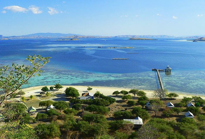
Tourism
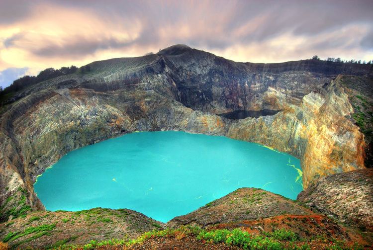
In 2016 East Nusatenggara got 6 medals from 10 categories of Anugerah Pesona Indonesia 2016. Gold medal of Most Popular Surfing Spot of Nemberala Beach, Rote Ndao Regency; Gold medal of Most Popular Cleanliness of Nihiwatu Beach, West Sumba Regency; Gold medal of Most Popular of Historical Site of Ende Bung Karno (Proclamator and the first Indonesia President) Site; Gold medal of Most Popular Diving Site of Alor Island, Alor Regency; Silver medal of Most Popular Attraction of Pasola, Southwest Sumba Regency; Bronze medal of Most Popular Highland of different color of three lakes/calderas of Mount Kelimutu, Ende.
The provincial government aims to promote tourism. There are various interesting locations in the province. The basic infrastructure to support the tourist sector (such as transport facilities, accommodation, and adequate and reliable information) needs to be strengthened but several main features of the tourist sector in the province include:
Various local community groups in the province work to promote the local tourist industry although, as yet, many of these activities are still somewhat underdeveloped and need strengthening.
Well-known figures
Well-known figures from the province include the following: