
Country Capital Oskemen | Area 283,226 km2 Founded 1932 | |
 | ||
Map of East Kazakhstan Region
East Kazakhstan Region (Russian: Восточно-Казахстанская область, Kazakh: Шығыс Қазақстан облысы, Şığıs Qazaqstan oblısı, شىعىس قازاقستان وبلىسى) is a region of Kazakhstan. It occupies the easternmost part of Kazakhstan, along both sides of the Irtysh River and Lake Zaysan. Its administrative center is Oskemen (also known as Ust-Kamenogorsk). The region borders Russia in the north and northeast and the People's Republic of China (Xinjiang Uighur Autonomous Region) in the south and southeast. The easternmost point of the Oblast is within about 50 kilometres of the westernmost tip of Mongolia; however, Kazakhstan and Mongolia do not share a common border, the two countries being separated by a small part of Russia and China.It also borders the Kazakh regions of Pavlodar Region (to the north west), Karaganda Region (to the west), and Almaty Region (to the south).
Contents
- Map of East Kazakhstan Region
- east kazakhstan region tourism in english language
- One night in the east kazakhstan region timelapse
- Nature
- Demographics
- Administrative divisions
- Sport
- References
Population: 1,396,593 (2009 Census results);1,531,024 (1999 Census results). 318,800 (as of 4/1/2011) live in the capital. The area has many Russians and Ukrainians; the capital itself has more of those two groups than Kazakhs themselves. The area is 283,300 square kilometers.
The region was created by the merger of two Soviet-era Kazakhstan oblasts: the old Vostochno-Kazakhstanskaya (East Kazakhstan) Oblast and Semipalatinsk Oblast.
east kazakhstan region tourism in english language
One night in the east kazakhstan region timelapse
Nature
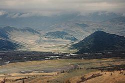
The region occupies a very diverse range of geographic and climatic regions with the Altai Mountains in the east and the eastern margins of the Kazakh steppes in the west of the region.
Demographics
55% of the population is ethnic Kazakh and 41% is ethnic Russian.
Administrative divisions
The region is administratively divided into fifteen districts and the cities of Oskemen (Ust-Kamenogorsk), Ayagoz, Kurchatov, Ridder, Semey (Semipalatinsk), and Zyryanovsk.
- Abay District, with the administrative center in the selo of Karauyl;
- Ayagoz District, the town of Ayagoz;
- Beskaragay District, the selo of Beskaragay;
- Borodulikha District, the selo of Borodulikha;
- Glubokoye District, the settlement of Glubokoye;
- Katonkaragay District, the selo of Ulken Narym;
- Kokpekti District, the selo of Kokpekti;
- Kurshim District, the selo of Kurshim;
- Shemonaikha District, the town of Shemonaikha;
- Tarbagatay District, the selo of Aksuat;
- Ulan District, the settlement of Molodyozhny;
- Urzhar District, the selo of Urzhar;
- Zaysan District, the town of Zaysan;
- Zharma District, the selo of Kalbatau (Georgiyevka);
- Zyryan District, the town of Zyryanovsk.
* The following ten localities in East Kazakhstan Region have town status: Oskemen (Ust-Kamenogorsk), Ayagoz, Charsk (Shar), Kurchatov, Ridder, Semey (Semipalatinsk), Serebryansk, Shemonaikha, Zaysan, and Zyryanovsk.
Sport
The region sent a bandy team to the Spartakiade 2009 and finished third.