
 | ||
Government Region government, National government | ||
Conference on the development of the regions of kazakhstan 2014
Kazakhstan is divided into 14 regions (Kazakh: облыстар / oblıstar; singular: облыс / oblıs; Russian: области / oblasti; singular: область / oblast' ). The regions are further subdivided into districts (Kazakh: аудандар / awdandar; singular: аудан / awdan; Russian: районы / rayony; singular: район / rayon ). Three cities, Baykonur, the largest city Almaty and the capital Astana are not part of the regions they are surrounded by.
Contents
- Conference on the development of the regions of kazakhstan 2014
- Former Administrative Boundaries
- References
Former Administrative Boundaries
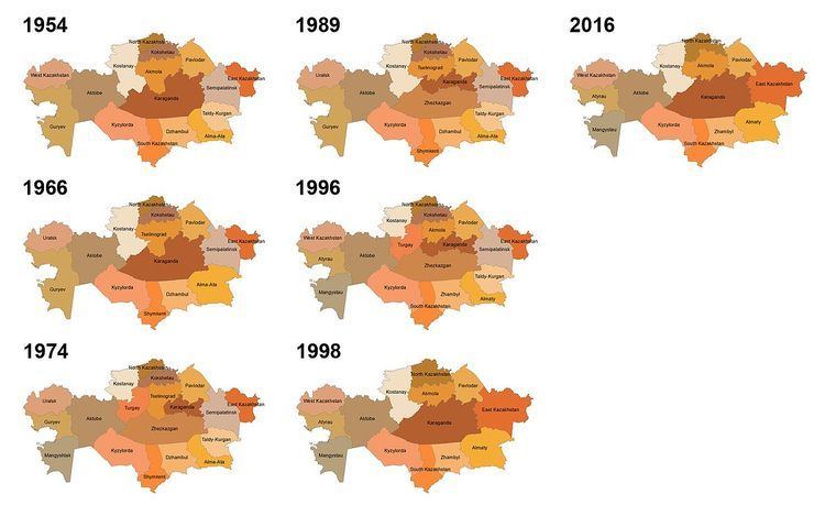
Over the last 60 years, both the distribution and names of regions of Kazakhstan have changed considerably. Major changes were several fusions and splits between Guryev and Mangystau, Karaganda and Dzhezkazgan, Almaty and Taldy-Kurgan, East Kazakhstan and Semipalatinsk and Kostanay, Turgay and Tselinograd, respectively. Changes in region names were often in line with the renaming of cities, such as in the case of Alma-Ata/Almaty. After the administrative reform in 1997, the last change happened since then took place in 1999, when parts of North Kazakhstan that originally belonged to Kokshetau region became part of Akmola. The 1990s merges were in order to dilute Russian population in the resulting region and to avoid having regions where Russians form majority.