
 | ||
Earthquakes have occurred in Western Australia (WA) on a regular basis throughout its geological history.
Contents
- Recording
- Significant earthquakes
- Exmouth 1906
- Kalgoorlie 1917
- Meeberrie Station 1941
- Yallingup 1946
- Gabalong 1955
- Busselton 1959
- Near Brookton 1963
- Meckering 1968
- Lake Tobin 1970
- Calingiri 1970 1971
- Cadoux 1979
- Collier Bay 1997
- Burakin Swarm 200001
- South of Albany 2001
- Kalgoorlie 2010
- References
In 1849, the first earthquake following European settlement in WA was recorded. "On Saturday last, about a quarter past four o'clock a.m., several inhabitants of Perth were awoke by what they conceived to be a slight shock of an earthquake."
The largest earthquake (magnitude 7.2 – 7.3) documented occurred in 1941, at Meeberrie, in the Murchison region. Like many earthquakes it remained little known, due to its lack of impact on urban areas. Because the Meckering earthquake of 1968 caused injuries to at least 17 people and extensive property damage, it is the best-known earthquake.
Recording
Prior to scientific equipment being utilised to record earthquakes, newspaper reports appear to be the main source of historical information. Perth Observatory was the recording location from 1923 to 1959, when the Mundaring Geophysical Observatory was operated by the Bureau of Mineral Resources between March 1959 and April 2000. Subsequent to the closing of the Mundaring observatory, recording locations are more dispersed throughout the state.
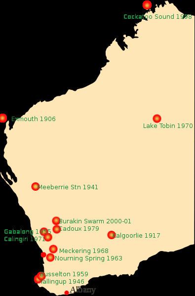
Significant earthquakes
Western Australia's largest recorded earthquake to date was at Meeberrie station, north of Mullewa, in April 1941. See the separate section below. The Cadoux earthquake of 1979 with magnitude 6.1 caused surface rupturing, about 15 km long.
Earthquakes at Meckering, Calingiri (several during 1970 and 1971) and Cadoux led to the identification of a zone of seismicity known as the South West Seismic Zone. This zone has now been significantly mapped and analysed and is the most active zone in Western Australia.
Exmouth 1906
The earthquake which occurred in 1906 about 400 km NW of Exmouth occurred before world earthquake monitoring had really developed. With an estimated magnitude of 7.5, it is probably the largest earthquake known to have occurred in the Australian region.
Kalgoorlie 1917
On 28 August 1917, tremor was reported near midnight in Kalgoorlie, which resulted in an underground rock fall, killing one miner and injuring several others. Also in the 1990s further seismic activity required consideration of seismic activity.
Meeberrie Station 1941
The largest earthquake to date in Western Australia was on 29 April 1941 at Meeberrie at 01.35.39 am (Lat -26.90 and Long 115.80) with a magnitude of 7.3. (Some sources give 7.2.)
Yallingup 1946
On 20 April 1946 a magnitude 5.7 earthquake occurred near Yallingup at 9:13pm on 19 April 1946 (5:13 local time on 20 April), which was felt at Kirup. A tremor was reported at 5:30 am at Caves House Yallingup and at Busselton on 30 April, which is probably the same event, reported on the wrong date.
Gabalong 1955
Gabalong, 30 August 1955, magnitude 5.8 Gabalong, a small community about 30 km east of Moora and 200 km NNE of Perth. The earthquake, at 9.52 pm local time, was felt at MM VI at Yericoin and Miling, and MM V in Moora. It was felt in Perth at intensities between MM II and MM IV, and at Dongara at MM II. It was preceded by a magnitude 5.3 earthquake at the same location at 2.09 pm on the same day. It was a SouthWest Seismic Zone earthquake, and because of the poor location capabilities at the time, may well be related to a series of earthquakes near Yericoin, which started with a magnitude 5.1 earthquake on 2 May 1949.
Busselton 1959
A magnitude 5.0 earthquake occurred at 12:07 GMT on 3 October (8.07 pm local time) at 34.5 degrees south, 114.5 degrees east. It was felt at Busselton, Yallingup, Margaret River, Bunbury, Cape Naturaliste and Cape Leeuwin.
Near Brookton 1963
18 January 1963 at Nourning Spring, approximately 20 km NE of Brookton and approximately 100 km ESE of Perth. It was felt at Intensity VII at Nourning Springs, VI at Brookton, and MM II at Perth. It occurred at 1:49 pm local time, and had a magnitude of 5.4, although it was given a magnitude of 4.9 originally. Many earthquake questionnaires were distributed for this event, and a good isoseismal map was prepared.
Meckering 1968
See Meckering
Lake Tobin 1970
24 March 1970, magnitude 6.7 near Lake Tobin in the Canning Basin, was the first in a location which had many more earthquakes over the following years. In all, there were three earthquakes of magnitude 6.0 or more (24/3/70, M 6.7, 16/7/71, M6.4 and 3/10/75, M 6.2), and 25 earthquakes of magnitude 5.0 or more, the last of which occurred on 13/2/1982.
Calingiri 1970 & 1971
See Calingiri
Cadoux 1979
See Cadoux
Collier Bay 1997
This earthquake, 10 Aug 1997, magnitude 6.3 just off the WA north coast, was the largest Australian earthquake since the magnitude 6.7 earthquake near Tennant Creek, in the Northern Territory, in January 1988.
Burakin Swarm 2000–01
Located near Cadoux (but not on the same physical feature) the Burakin event was named the most significant seismic activity in 40 years.
South of Albany 2001
This very large earthquake on 12 Dec 2001, magnitude 7.1 occurred about 1000 km southeast of Albany. It was felt in Albany. It was an intraplate earthquake, as it occurred about 1000 km north of the (constructive) boundary between the Indo-Australian and Antarctic plates.
Kalgoorlie 2010
On 20 April 2010, a magnitude 5.0 earthquake occurred close to Kalgoorlie. The quake caused damage to a number of hotels along Burt street in Boulder and an underpass also on Burt street collapsed, work in the Superpit and many other mines around Kalgoorlie was stopped.