Easiest route Scramble, class 2 Prominence 116 m | Elevation 2,372 m Mountain range Sierra Nevada Parent range Sierra Nevada | |
 | ||
Similar North Dome, Mount Hoffmann, Sentinel Rock, Mount Morgan, Mount Pinchot | ||
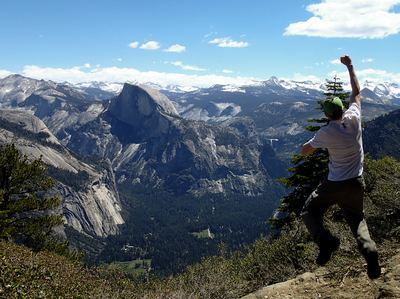
Eagle Peak is the highest of the Three Brothers, a rock formation, above Yosemite Valley in California. This independent peak is located just east of El Capitan. John Muir considered the view from the summit to be "most comprehensive of all the views" available from the north wall.
Contents
Map of Eagle Peak, California 95389, USA
RecreationEdit
Eagle Peak can be reached by following the Upper Yosemite Falls and Eagle Peak trails. The hike is 6.0 miles (9.7 km) one way with a climb of over 3,500 feet (1,100 m). The trailhead is at Camp 4 near Yosemite Village. It passes near Yosemite Falls and affords many views of the valley.
The peak can also be reached form the Tamarack Flat Campground located off the Tioga Pass Road. The hike, which follows the El Capitan trail most of the way, is 7.7 miles (12.4 km) but the trailhead is at about 6,400 feet (2,000 m). Another route starts at Yosemite Creek Campground at an elevation of 7,200 feet (2,200 m). This trailhead is at the end of a very rough, single lane, 4-mile (6.4 km) road.
