
Elevation 3,773 m Mountain range Sierra Nevada Parent range Sierra Nevada | Topo map USGS Dunderberg Peak Prominence 407 m Easiest route Hiking | |
 | ||
Similar Matterhorn Peak, Mount Gibbs, North Peak, Mount Dana, Vogelsang Peak | ||
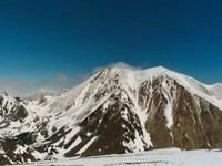
Dunderberg Peak is located east of the Sierra Nevada crest near the divide between the Owens and E. Walker Valleys (Conway Summit) in Mono County, in eastern California in the southwestern United States. The peak is in the Hoover Wilderness and is the highest point in Humboldt-Toiyabe National Forest.
Contents
Map of Dunderberg Peak, California 93541, USA
HistoryEdit
Dunderberg Peak, originally named Castle Peak, was renamed by a party of the Wheeler Survey after the mines upon its northerly slope in 1878.
References
Dunderberg Peak Wikipedia(Text) CC BY-SA