
SATCAT no. 35682 Mission duration 5 years Inclination 98.13° Period 1.6 hours | COSPAR ID 2009-041B Website mbrsc.ae/en Launch date 29 July 2009 Inclination 98.13° | |
Operator Mohammed Bin Rashid Space Centre Similar DubaiSat‑2, Nanosat‑1B, RazakSAT, Deimos‑1, UK‑DMC 2 | ||
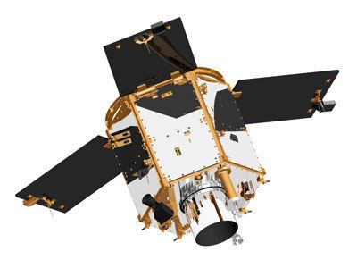
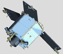
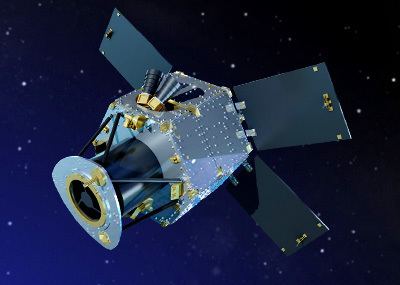
DubaiSat-1 is a remote sensing Earth observation satellite built by the Emirates Institution for Advanced Science and Technology (EIAST) under an agreement with Satrec Initiative, a satellite manufacturing company in South Korea. The earth observation satellite was designed and developed by Satrec Initiative, with participation from EIAST engineers.
Contents
- Overview
- Structure
- Ground Station Components
- The Antenna and RF Subsystem
- The Mission Control Station
- Image Receiving and Processing Station
- Infrastructure development
- Environmental
- Disaster relief
- Future plans
- Gallery
- References
DubaiSat-1 was launched on July 29, 2009 into a 680 km altitude sun-synchronous polar orbit from the Baikonur launch site in Kazakhstan, along with several other satellites on board the Dnepr launch vehicle.
Overview
DubaiSat-1 observes the earth at a Low Earth orbit (LEO) and generates high-resolution optical images at 2.5m in panchromatic and at 5m in multispectral bands. These images provide decision makers in the UAE as well as EIAST clients with a valuable tool for a wide range of applications including infrastructure development, urban planning, and environment monitoring and protection. DubaiSat-1 images are also useful for promoting geosciences and remote sensing research in the region, and for supporting different scientific disciplines in private and academic sectors.
For example, DubaiSat-1 images have been used, to monitor progress on the Dubai World Megaproject, Palm Islands, and the Al Maktoum International Airport.
The United Nations also used DubaiSat-1 images to monitor relief efforts following the 2011 Tōhoku earthquake and tsunami in Japan.
The satellite accommodates two main payloads. The primary payload is the Dubai Medium Aperture Camera (DMAC), and the secondary and experimental payload, the Space Radiation Monitor (SRM).
The DMAC system is pushbroom imaging system with one panchromatic and four multi-spectral imaging channels. It also consists of an Electro-Optical Subsystem and the Payload Management Subsystem. The Electro-Optical Subsystem has a telescope, a focal plane assembly, and a Signal Processing Module. The Payload Management Subsystem consists of the Thermal & Power Module and the Mass storage & Control Module.
The Space Radiation Monitor, the secondary and experimental payload, is capable of measuring the total ionizing dose from the charged particles at the orbits of satellites. The instrument utilizes four p-type Metal-Oxide-Semiconductor Field Effects Transistors (MOSFETs). These devices measure the current-voltage characteristics of the satellite. Subsequent analysis will allow measurements of the amount of cumulative ionizing dose, and of the total ionizing dose of the devices.
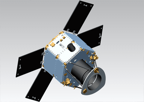
Structure
DubaiSat-1 has a hexagonal body with three deployable solar panels. The frame includes spacecraft adaptors, six longerons, rails, an inner ring that provides rigidity and stability of the satellite's camera, inner rods and three decks. Three spacecraft adaptors connect with shear brackets and mechanically couple the satellite and separation adaptor of the launch vehicle, the Dnepr Rocket. Each one of the spacecraft adaptors has separation sensors to monitor the separation condition between the satellite and the launch vehicle. The umbilical connector attaches on the lower surface of the bottom deck with its mounting support bracket.
Ground Station Components
EIAST's Ground Station is located in Dubai, and is the only ground system supporting the DubaiSat-1 mission. The ground system consists of three main subsystems:
The Antenna and RF Subsystem
The Antenna and RF subsystem consists of an 11.28 meter antenna system, an S-band transmitter feed, an S-band receiver feed, an X-band receiver feed, and a tracking system. The RF equipment, including transmitting and receiving antennas, are used to communicate with the satellite. The Antenna & RF subsystem receives X-band RF signals and performs RF processing. It also produces a demodulated and bit-synchronized data stream from X-band signals. In general, the main functions of the antenna & RF subsystem are to transmit imaging orders and command the satellite through the S-band transmitter feed; receive information and health status from the satellite through the S-band receiver feed; and download the images through the X-band feed.
The Mission Control Station
From the Mission Control Station, EIAST staff plan and operate the entire space mission, including the configuration and scheduling of resources for both space and ground elements. It also monitors and commands the satellite.
Image Receiving and Processing Station
The third component of the ground system is the Image Receiving and Processing Station (IRPS). The IRPS receives and processes the X-band downlink data in real-time. This includes generation of standard image products and catalogues for integration with system management; for archive management; and for comprehensive user interface to provide easy access to satellite image data.
The IRPS is located at EIAST’s ground station in Dubai, UAE. It has a direct interface with the main mission control station and it generates schedule requests which includes imaging and download schedules. It also archives image and ancillary data for product generation and distribution.
Infrastructure development
Satellite imagery provides an alternative way of looking at the world. It can add significant incremental data useful in a wide range of applications. The high-resolution spatial images can complement the existing geographic information system databases too.
DubaiSat-1 images support infrastructure development in the UAE and the Persian Gulf region. These images assist decision makers involved in urban and rural planning, transportation, utilities and mapping. Some images were also useful for monitoring progress on the Dubai World Megaproject, Palm Islands and the Al Maktoum International Airport.
Environmental
Many environmental and meteorological events such as vegetation stress, fog, land degradation, sandstorms, desertification and droughts cannot be captured by ground measurements alone, making remote sensing an important tool in environmental monitoring. The sun-synchronous orbit of DubaiSat-1 merges with data from geostationary missions to provide enhancements on existing models.
Additionally, due to their low precipitation rates, arid regions are the world’s major source of atmospheric dust that affects local, regional and global climate. Dust and sand storms create potentially hazardous air quality for humans, and adversely affect climate on regional and worldwide scales. Remote sensing is a demonstrably valuable tool for detecting, mapping and forecasting such events. However arid and semi arid regions have their own specific and unique characteristics and vulnerabilities that require special attention when adapting existing remote sensing tools efficiently. Satellite imaging helps monitor and improve management of the world’s agricultural resources. Multispectral images contribute by monitoring land use, generating vegetation indices, and monitorong water quality.
Disaster relief
Satellite images are useful tools to assist disaster relief teams to determine how to tackle rescue and recovery efforts in the wake of catastrophic natural, or even man-made, events. In the aftermath of the tsunami in Japan on March 11, 2011, EIAST applied DubaiSat-1 to help disaster relief teams determine and manage the scale of the event.
Future plans
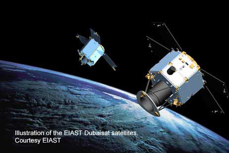
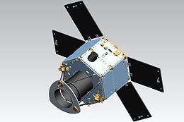
DubaiSat-2 is an electro-optical earth observation satellite system to be launched and operated by Emirates Institution for Advanced Science and Technology. The spacecraft will have a ground sampling distance of 1 meter at 600 km in a sun-synchronous orbit. DubaiSat-2 will have the capacity to store approximately 17,000 km2 of image data. It is relatively small, weighing less than 300 kg and suitable for commercial use within the UAE or other regions worldwide. The electro-optical payload is a push-broom camera with TDI sensors.
The Launch was scheduled for the fourth quarter of 2012 and is ready, but launch practicalities will move it into 2013. DubaiSat-2 also includes an experimental propulsion system for orbit correction and maintenance. The satellite’s expected lifetime is at least five years. The modules in the satellite use two CAN Bus networks to communicate with each other without the use of a host computer.
Gallery
The following are some of the satellite images taken by DubaiSat-1: