
 | ||
Points of interest Aquaventure Waterpark, Palm Jumeirah Islands Palm Jumeirah, Deira Island, Palm Jebel Ali Similar Palm Jumeirah,Palm Jebel Ali, Deira Island | ||
For the islands in Lebanon see Palm Islands Nature Reserve
Contents
- Map of Palm Islands Dubai United Arab Emirates
- Palm JumeirahEdit
- Palm Jebel AliEdit
- Environmental concernsEdit
- Structural importanceEdit
- Key people involved in the construction processEdit
- Main constraintsEdit
- Project risks and threatsEdit
- Hidden problemsEdit
- Obstacles after the island constructionEdit
- Risk mitigationEdit
- Construction effects and repercussionsEdit
- Remedial measure to protect the coastEdit
- Geo LinksEdit
- References
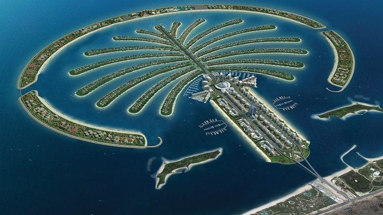
Map of Palm Islands - Dubai - United Arab Emirates
Palm Islands are three artificial islands, Palm Jumeirah, Deira Island and Palm Jebel Ali, on the coast of Dubai, United Arab Emirates. As of November 2014, only Palm Jumeirah has been completed. This island takes the form of a palm tree, topped by a crescent. After completion, Palm Jebel Ali will take a similar shape; each island will be host to a large number of residential, leisure and entertainment centers and will add a total of 520 kilometers of non-public beaches to the city of Dubai.
The creation of the Palm Islands began in June 2001. Shortly after, the Palm Islands was announced and reclamation work began. This island was meant to be a bigger island, but it was later downsized. An island was planned and construction started, but this project was later remodelled and renamed to The Palm Islands.
Palm JumeirahEdit
The Palm Jumeirah ( Coordinates: 25°06′28″N 55°08′15″E ) consists of a tree trunk, a crown with 16 fronds, and a surrounding crescent island that forms an 11 kilometer-long breakwater. The island itself is five kilometers by five kilometers. It adds 78 kilometers to the Dubai coastline.
Residents began moving into Palm Jumeirah properties at the end of 2006, five years after land reclamation began.The Palm Island address is considered a status symbol in Dubai.
A Monorail opened in 2009, but is not connected to other public transport.
Palm Jebel AliEdit
The Palm Jebel Ali began construction in October 2002 and was expected to be completed in mid-2015.
Environmental concernsEdit
The construction of the Palm Islands has had a significant impact on the surrounding environment, resulting in changes to area wildlife, coastal erosion, alongshore sediment transport and wave patterns. Sediment stirred up by construction has suffocated and injured local marine fauna and reduced the amount of sunlight which filters down to seashore vegetation. Variations in alongshore sediment transport have resulted in changes in erosion patterns along the UAE coast, which has also been exacerbated by altered wave patterns as the waters of the Persian Gulf attempt to move around the new obstruction of the islands.
Dubai's megaprojects have become a favorite cause of environmentalists. Greenpeace has criticized the Palm Islands for lack of sustainability, and Mongabay.com, a site dedicated to rain forest conservation, has attacked Dubai's artificial islands aggressively, stating that:
significant changes in the maritime environment [of Dubai] are leaving a visual scar [... ] As a result of the dredging and redepositing of sand for the construction of the islands, the typically crystalline waters of the Persian Gulf at Dubai have become severely clouded with silt. Construction activity is damaging the marine habitat, burying coral reefs, oyster beds and subterranean fields of sea grass, threatening local marine species as well as other species dependent on them for food. Oyster beds have been covered in as much as two inches of sediment, while above the water, beaches are eroding with the disruption of natural currents.
Structural importanceEdit
Palm Jumeirah was built entirely from sand and rocks (no concrete or steel was used to build the island). This was done in accordance with the order of the Prince of Dubai, who came up with the idea for the Palm Islands, as well as their design.
The primary objective for the construction of the Palm Islands was to create a major tourist destination in Dubai in to compensate for a decrease in revenue from oil as oil reserves in the Persian Gulf depleted. Palm Jumeirah is host to a hotel, Atlantis.
Key people involved in the construction processEdit
Main constraintsEdit
Project risks and threatsEdit
Hidden problemsEdit
Obstacles after the island constructionEdit
Installation of utilities and pipelines were very difficult and laborious.
Risk mitigationEdit
To counteract with the waves and the constant motion of the sea, wave blockers were built all around the palm island. They were 3 meters high and 160 kilometers in total length. Expanded over a length of about 11.5 kilometers, the base of these stoppers and the island as such were constantly monitored during construction process with the help of deep sea divers. They check for the proper alignment and placement of the rocks beneath the surface to ensure its stability. Shape of the island as it got developed in the middle of the sea was constantly monitored using the global positioning system (the satellite was placed about 676 kilometres from sea level into space). The sand on top of the island was sprayed by a technique called rainbowing. Here the sand from the dredging ships was sprayed on to the land. The whole island was set such that there was no stagnant water between the island and the water breakers. So in order to achieve this, there were small structural modifications done on the breakers that outlined the island. Hence making the sea water to move through in and out of the breakers without causing any damage to the island. To prevent erosion of the soil from the island, there were constant maintenance setups to spray soil along the coast of the island and also along the Dubai coast. Coastal ecology was recovered with the help of nature itself. These changes began attracting newer species of fishes and also reef formations. Every 6 weeks sea divers go down under water to check the marine life as part of their monitoring process. Precautions were also taken to prevent the process of liquifaction of the sand on the island (below the upper surface). This process of liquifaction was caused due to movement of the rocks and sand and also under water erosions before and after construction. Vibro-compaction technique was the method that was employed to prevent the process of liquifaction. This was carried out in order to hold the composition of the island's base together and also to make a strong foundation for further constructions.
Construction effects and repercussionsEdit
The construction of the Palm islands along the coast of Dubai has caused several large environmental changes: a reduction in the area's aquatic life, erosion of the coastal soil, and irregular sediment transport along the shore. There is also a dramatic change in wave patterns along the coast of Dubai due to the rock walls constructed around the palm islands: instead of hitting the shores directly, the waves move in an unusual manner around the new obstruction. This has led to the weakening of the shores of Dubai.
Most of the environmental damage was caused by the sediments stirred up by the construction; it suffocated and injured the surrounding marine fauna and decreased the amount of sunlight filtering down to the sea vegetation. Such environmental disturbances have turned the heads of many environmental activists. Greenpeace and Mongabay.com (Rain forest conservation organization) have expressed very strong opinions against the building of the Dubai Palm islands.
The World Wildlife Fund announced in 2006, "[The] UAE's human pressure on global ecosystems (its ecological footprint) [is] the highest in the world. The country is supposedly at present five times more unsustainable than any other country" (Samarai 2007). It also mentioned that the construction from the start up to date had caused many visible ecological and environmental changes that were a threat to the future.
Remedial measure to protect the coastEdit
To properly manage their shorelines and effects, Dubai relies on its coastal monitoring program. Established in 1997, the Dubai coastal monitoring program began studying the baseline bathymetric (measurement of depth of water in oceans or seas) and topographic survey of the Jumeirah (Dubai) coastline.
Additional data were collected with technological improvements including remote video monitoring of Dubai beaches, sediment sampling and analysis, near shore directional wave and current recordings and intensive measurement exercises at selected locations using Acoustic Doppler Current Profiler (ADCP) equipment. This way they were able to do a constant monitor and check on the continuously changing environmental conditions along the coast of Dubai.
Geo LinksEdit
Ideally Geo Links should be integrated into the main article.