
Length 2 mi (3 km) Sight Grand Canyon | Elevation change 1,180 ft (360 m) | |
 | ||
Trailheads Hermit TrailEremita Mesa, South Rim Highest point Eremita Mesa, 6,420 ft (1,960 m) Similar Castle Creek Wilderness, Wolf Creek Falls, Hermit Trail, Groom Creek Loop Trai, Grand Canyon | ||
Dripping springs trail
The Dripping Springs Trail is a hiking trail on the South Rim of the Grand Canyon National Park, located in the U.S. state of Arizona.
Contents
- Dripping springs trail
- Hot dry thirsty hike on agua tibia via dripping springs trail in cleveland national forest
- Access and description
- References
Hot dry thirsty hike on agua tibia via dripping springs trail in cleveland national forest
Access and description
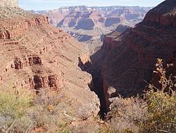
The trail begins along the Hermit Trail after a 1 1⁄2 miles (2.4 km) hike from Hermit's Rest.
From Hermit Trail, the trail leaves the Hermit Basin and crosses to the western side of Hermit Canyon towards Dripping Springs. After another 1 1⁄4 miles (2.0 km) the trail crosses the Dripping Springs drainage and connects to the Boucher Trail, which leads to the north along the eastern side of Hermit Canyon.
The Dripping Springs Trail continues westward from the trail junction for another 1⁄2 mile (0.80 km), climbing back out of the Hermit Shale and Coconino Sandstone layers to Dripping Springs, a perennial water source. Water from here needs to be treated, filtered, or boiled prior to consuming. After the springs, the trail continues to the south rim on Eremita Mesa and the trail's western terminus. Eremita Mesa is a remote area of the park and provides no access back to Grand Canyon Village or Hermit's Rest except by unmaintained gravel roads.