
Elevation 729 m (2,392 ft) Area 5.69 km² Population 410 (31 Dec 2008) Dialling code 07335 | Time zone CET/CEST (UTC+1/+2) Local time Saturday 9:52 AM Postal code 73345 | |
 | ||
Weather 4°C, Wind SE at 11 km/h, 60% Humidity | ||
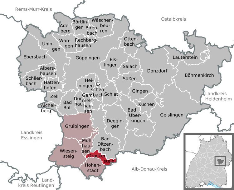
Drackenstein is a municipality in the district of Göppingen in Baden-Württemberg in southern Germany.
Contents
- Map of Drackenstein Germany
- Geographical location
- Neighboring communities
- Municipality arrangement
- History
- Population Development
- References
Map of Drackenstein, Germany
Geographical location
Drackenstein is located on the slope between the Gosbach valley and the plateau of the Swabian Jura, about 25 km away from the district town Göppingen. On the plateau of the Swabian Jura, (karst mountains), in earlier times water was a precious commodity. Therefore, there was in Unterdrackenstein a Hydraulic ram, that pumped water to Oberdrackenstein. By connecting to the Lake Constance water supply in the 20th century these problems belong to the past. At the opposite Drackensteiner Hang the Bundesautobahn 8 runs towards Stuttgart. There was the dragon hole, a cavity, which was filled in during the construction of the motorway. It is believed that the name of the community goes back to a legend of the dragon hole.
Neighboring communities
The municipality borders on Bad Ditzenbach, in the southeast on Merklingen, in the southwest on Hohenstadt and in the west on the town Wiesensteig and the municipality Mühlhausen im Täle. Merklingen belongs to Alb-Donau-district, all others to Göppingen district.
Municipality arrangement
The municipality includes the village Oberdrackenstein, the hamlet Unterdrackenstein and the homestead Kölleshof.
History
Drackenstein was first documented in a chronicle of the Zwiefalten Abbey from the year 1137. See also: Castle Drackenstein
Population Development
The inhabitants of the community development 1837-2010.