
Range Bookcliff Mountains Elevation 2,520 m | Topo map USGS Douglas Pass | |
 | ||
Similar Rocky Mountains, Monarch Pass, McClure Pass, Wolf Creek Pass, Fremont Pass | ||
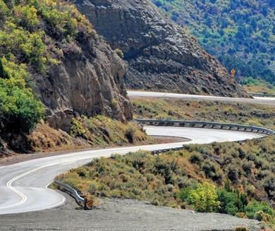
Douglas Pass (elevation 8268 feet) is a mountain pass in Colorado traversed by State Highway 139. It is not an especially high summit relative to other Colorado passes, and the road, though reasonably steep on the south side (7%), has no tight spots and only a few switchbacks. The summit gives an unusual view of the northeast face of the LaSal Mountains (twelve peaks over 12,000 feet) at 95 air miles away in Utah. The remainder of the drive is basically in valleys following creeks.
Map of Douglas Pass, Colorado 81630, USA
The mountain consists of shale strata belonging to the Green River Formation, good exposures of which can be seen on the south side of the pass. The shale can easily slide onto the road surface throughout the year. The two-lane highway receives much truck traffic due to gas and oil development in the general area, and the Colorado Department of Transportation does not maintain the road at night, which can increase road hazards, especially in the winter.
On 2 October 2004, rancher Russel Jay Yount was driving cattle on the pass and found a skull near the summit. Forensic Odontologist Dr. John Bull, of Grand Junction, Colorado, later confirmed the skull to be that of murder victim Sabrina Bebb-Jones, murdered in September 1997, through dental records.