
Time zone EST (UTC-5) Elevation 40 m | Area code(s) (416) and (647) Community Scarborough | |
 | ||
Restaurants Ni Ji Sushi Japanese Restaurant, Pho Vietnam, Habibiz Restaurant & Cafe, Cafe Mirage Grill & Lounge, Karaikudi Chettinad Restaurant | ||
Treb mls e3430410 condo townhouse dorset park toronto ontario canada
Dorset Park is a neighbourhood in Toronto, Ontario, Canada. It is located east of the central core, in the former suburb of Scarborough. The neighbourhood is bordered by Highway 401 to the North, Midland Avenue to the East, Lawrence Avenue to the South, Birchmount Road to the west, and Kennedy Road running along the centre North and South and Ellesmere Road running along the centre East and West of the neighbourhood. The area south of Lawrence Avenue, north of the hydro corridor is known as McGregor Park and is often included as part of Dorset Park.
Contents
- Treb mls e3430410 condo townhouse dorset park toronto ontario canada
- Map of Dorset Park Toronto ON Canada
- Area description
- Historical background
- References
Map of Dorset Park, Toronto, ON, Canada
Area description
The main high school in the area is Winston Churchill Collegiate Institute located in the south end of the neighbourhood. The business district of Scarborough seems to be carried right through the heart of Dorset Park along Kennedy Road from Highway 401 to Lawrence Avenue. The business district along Kennedy Road is a 3.5 kilometre stretch of the road with nothing but stores/business and high rise buildings. Kennedy Commons, a large strip mall is located on Kennedy Road, in between Highway 401 and Ellesmere Road.
Historical background
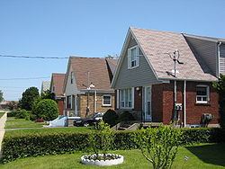
The area was formerly agricultural in nature, with the majority of the housing built in the 1950s.